
Carte topographique Cookham Rise
Cliquez sur la carte pour afficher l’altitude.
À propos de cette carte
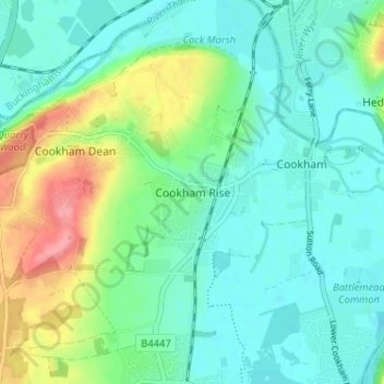
Nom : Carte topographique Cookham Rise, altitude, relief.
Altitude moyenne : 44 m
Altitude minimum : 19 m
Altitude maximum : 110 m
Autres cartes topographiques
Cliquez sur une carte pour visualiser sa topographie, son altitude et son relief.
Windsor Castle
United Kingdom > England > Royal Borough of Windsor and Maidenhead > Windsor > Clewer Village
Altitude moyenne : 23 m
Windsor Marina
United Kingdom > England > Royal Borough of Windsor and Maidenhead > Oakley Green
Altitude moyenne : 26 m
Sunningdale
United Kingdom > England > Royal Borough of Windsor and Maidenhead
Altitude moyenne : 61 m
Wraysbury
United Kingdom > England > Royal Borough of Windsor and Maidenhead
The new chapel, with its elegant slender tower, was opened on 16 October 1862; the building works had cost around £800. The striking terracotta relief panel, The City of Refuge, on the front elevation of the chapel, was created by the renowned Doulton & Co artist George Tinworth and is signed with his…
Altitude moyenne : 25 m
Waltham St. Lawrence
United Kingdom > England > Royal Borough of Windsor and Maidenhead
Altitude moyenne : 44 m
White Waltham
United Kingdom > England > Royal Borough of Windsor and Maidenhead
Altitude moyenne : 41 m
Shottesbrooke
United Kingdom > England > Royal Borough of Windsor and Maidenhead
Altitude moyenne : 41 m
Magna Carta Island
United Kingdom > England > Royal Borough of Windsor and Maidenhead > Wraysbury
Altitude moyenne : 32 m
Old Windsor
United Kingdom > England > Royal Borough of Windsor and Maidenhead
Altitude moyenne : 38 m
Bridge Gardens
United Kingdom > England > Royal Borough of Windsor and Maidenhead > Maidenhead
Altitude moyenne : 30 m
Upton Court Park
United Kingdom > England > Royal Borough of Windsor and Maidenhead > Slough
Altitude moyenne : 23 m
Formosa Island
United Kingdom > England > Royal Borough of Windsor and Maidenhead > Cookham
Altitude moyenne : 48 m
Cox Green
United Kingdom > England > Royal Borough of Windsor and Maidenhead > Maidenhead
Altitude moyenne : 36 m
Horton
United Kingdom > England > Royal Borough of Windsor and Maidenhead > Horton
Altitude moyenne : 18 m
Windsor Castle
United Kingdom > England > Royal Borough of Windsor and Maidenhead > Windsor > Clewer Village
Altitude moyenne : 23 m
Windsor Castle
United Kingdom > England > Royal Borough of Windsor and Maidenhead > Windsor > Clewer Village
Altitude moyenne : 23 m
Sunningdale
United Kingdom > England > Royal Borough of Windsor and Maidenhead
Altitude moyenne : 61 m
Wraysbury
United Kingdom > England > Royal Borough of Windsor and Maidenhead
The new chapel, with its elegant slender tower, was opened on 16 October 1862; the building works had cost around £800. The striking terracotta relief panel, The City of Refuge, on the front elevation of the chapel, was created by the renowned Doulton & Co artist George Tinworth and is signed with his…
Altitude moyenne : 26 m
Windsor Castle
United Kingdom > England > Royal Borough of Windsor and Maidenhead > Windsor > Clewer Village
Altitude moyenne : 23 m