
Carte topographique Bochum-Mitte
Cliquez sur la carte pour afficher l’altitude.
À propos de cette carte
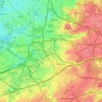
Nom : Carte topographique Bochum-Mitte, altitude, relief.
Lieu : Bochum-Mitte, Bochum, North Rhine-Westphalia, Germany (51.45937 7.14903 51.52185 7.25862)
Altitude moyenne : 91 m
Altitude minimum : 40 m
Altitude maximum : 143 m
Autres cartes topographiques
Cliquez sur une carte pour visualiser sa topographie, son altitude et son relief.
Bochum
Germany > North Rhine-Westphalia > Bochum
The city lies on the low rolling hills of Bochum land ridge (Bochumer Landrücken), part of the Ruhrhöhen (highest elevations) between the Ruhr and Emscher rivers at the border of the southern and northern Ruhr coal region. The highest point of the city is at Kemnader Straße (Kemnader Street) in Stiepel at…
Altitude moyenne : 107 m