
Carte topographique Lugoj
Carte interactive
Cliquez sur la carte pour afficher l’altitude.
À propos de cette carte
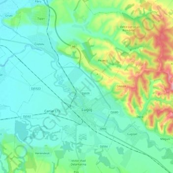
Nom : Carte topographique Lugoj, altitude, relief.
Lieu : Lugoj, Timiș, Romania (45.65025 21.82193 45.75990 22.03063)
Altitude moyenne : 145 m
Altitude minimum : 107 m
Altitude maximum : 272 m
The territory of Lugoj belongs to the high plain of Lugoj and the hills of Lugoj. Located in the contact area of these units, the city developed on the lower terrace of the Timiș River, on both its banks. The relief unit in which Lugoj is located is the Lugoj Plain, which penetrates deep into the piedmont hills. The average altitude of the area is 124 m (407 ft).
Autres cartes topographiques
Cliquez sur une carte pour visualiser sa topographie, son altitude et son relief.