
Carte topographique The Municipal District of Callan — Thomastown
Carte interactive
Cliquez sur la carte pour afficher l’altitude.
À propos de cette carte
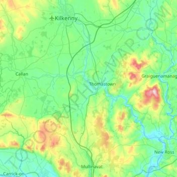
Nom : Carte topographique The Municipal District of Callan — Thomastown, altitude, relief.
Altitude moyenne : 100 m
Altitude minimum : -4 m
Altitude maximum : 500 m
Autres cartes topographiques
Cliquez sur une carte pour visualiser sa topographie, son altitude et son relief.
Graiguenamanagh
Graiguenamanagh, The Municipal District of Callan — Thomastown, County Kilkenny, Leinster, R95 EKN5, Irlande
Altitude moyenne : 138 m