
Faire un don
Équipez-vous pour votre prochaine aventure :
En tant que Partenaire Amazon, ce site perçoit une commission sur les achats éligibles sans surcoût pour vous.
Carte topographique Vadakara
Cliquez sur la carte pour afficher l’altitude.
Faire un don
Équipez-vous pour votre prochaine aventure :
En tant que Partenaire Amazon, ce site perçoit une commission sur les achats éligibles sans surcoût pour vous.
Vadakara
Vatakara is located at 11°36′N 75°35′E / 11.60°N 75.58°E / 11.60; 75.58 and has an average elevation of 15 m (49 ft). It is situated about 49 km to the north of Kozhikode City, approximately 44 km to the south of Kannur City, and adjacent to Mahé. The town lies by the side of a river variously called the Moorad river, the Kuttiady river, or Kottakkal river. The town's position relative to this river led to it being called Vadakkekara (north bank), later contracted to Vatakara. Towards the east, near the panchayats of Nadapuram and Kuttiady, Vadakara borders the Wayanad district along the Western Ghats section. In the west, like many of the towns in Kerala, Vatakara is flanked by the Arabian Sea. The Kuttiyadi river meets the sea to the south of Vatakara, forming small islands and sandbars near the river mouth.
Faire un don
Équipez-vous pour votre prochaine aventure :
En tant que Partenaire Amazon, ce site perçoit une commission sur les achats éligibles sans surcoût pour vous.
À propos de cette carte
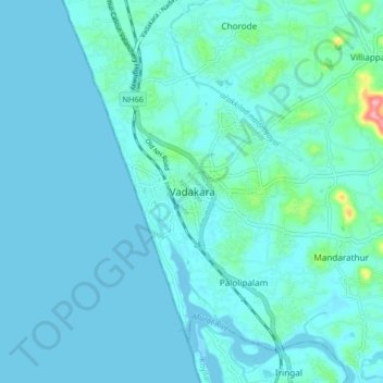
Nom : Carte topographique Vadakara, altitude, relief.
Lieu : Vadakara, Kozhikode District, Kerala, 670109, India (11.55707 75.55037 11.63707 75.63037)
Altitude moyenne : 12 m
Altitude minimum : -3 m
Altitude maximum : 121 m
Faire un don
Équipez-vous pour votre prochaine aventure :
En tant que Partenaire Amazon, ce site perçoit une commission sur les achats éligibles sans surcoût pour vous.