
Faire un don
Équipez-vous pour votre prochaine aventure :
En tant que Partenaire Amazon, ce site perçoit une commission sur les achats éligibles sans surcoût pour vous.
Carte topographique North East England
Cliquez sur la carte pour afficher l’altitude.
Faire un don
Équipez-vous pour votre prochaine aventure :
En tant que Partenaire Amazon, ce site perçoit une commission sur les achats éligibles sans surcoût pour vous.
North East England
North East England has a Marine west coast climate (generally found along the west coast of middle latitude continents) with narrower temperature ranges than the south of England and sufficient precipitation in all months. Summers and winters are mild rather than extremely hot or cold, due to the strong maritime influence of the North Atlantic Current of the Gulf Stream. The Met Office operates several weather stations in the region and are able to show the regional variations in temperature and its relation to the distance from the North Sea. The warmest summers in the region are found in Stockton-on-Tees and the Middlesbrough area, with a 1981-2010 July average high of 20.4 °C (68.7 °F). Precipitation is often low by English standards, in spite of the low levels of sunshine, with Stockton-on-Tees averaging only 574.2 millimetres (22.61 in) annually, and with the seaside town of Tynemouth (despite its slightly sunnier climate) recording 597.2 millimetres (23.51 in) annually. The summers on the northern coastlines are significantly cooler than in the southern and central inland areas: Tynemouth is only just above 18 °C (64 °F) in July. Further inland, frosts during winter are more common, due to the higher elevations and distance from the sea.
Faire un don
Équipez-vous pour votre prochaine aventure :
En tant que Partenaire Amazon, ce site perçoit une commission sur les achats éligibles sans surcoût pour vous.
À propos de cette carte
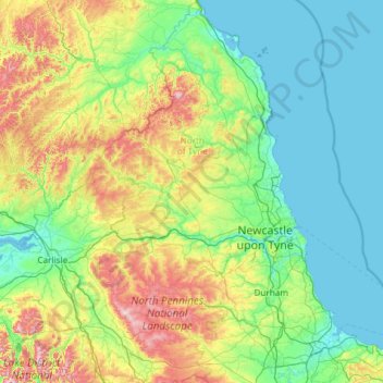
Nom : Carte topographique North East England, altitude, relief.
Lieu : North East England, England, United Kingdom (54.45113 -2.68981 55.81166 -0.78841)
Altitude moyenne : 165 m
Altitude minimum : -1 m
Altitude maximum : 921 m
Faire un don
Équipez-vous pour votre prochaine aventure :
En tant que Partenaire Amazon, ce site perçoit une commission sur les achats éligibles sans surcoût pour vous.
Autres cartes topographiques
Cliquez sur une carte pour visualiser sa topographie, son altitude et son relief.
Cambridge
United Kingdom > England > Cambridge
The city, like most of the UK, has a maritime climate highly influenced by the Gulf Stream. Located in the driest region of Britain, Cambridge's rainfall averages around 570 mm (22.44 in) per year, around half the national average, with some years occasionally falling into the semi-arid (under 500 mm (19.69…
Altitude moyenne : 18 m
Portsmouth
United Kingdom > England > Hampshire > Portsmouth
By road, Portsmouth lies 73.5 miles (118.3 km) from Central London, 49.5 miles (79.7 km) west of Brighton, and 22.3 miles (35.9 km) east of Southampton. Portsmouth is situated primarily on Portsea Island and is the United Kingdom's only island city, although parts of it have expanded onto the mainland. Gosport…
Altitude moyenne : 28 m
Faire un don
Équipez-vous pour votre prochaine aventure :
En tant que Partenaire Amazon, ce site perçoit une commission sur les achats éligibles sans surcoût pour vous.
Salisbury
United Kingdom > England > Salisbury
Bishop of Salisbury Hubert Walter was instrumental in the negotiations with Saladin during the Third Crusade, but he spent little time in his diocese prior to his elevation to archbishop of Canterbury. The brothers Herbert and Richard Poore succeeded him and began planning the relocation of the cathedral into…
Altitude moyenne : 96 m
Faire un don
Équipez-vous pour votre prochaine aventure :
En tant que Partenaire Amazon, ce site perçoit une commission sur les achats éligibles sans surcoût pour vous.
Faire un don
Équipez-vous pour votre prochaine aventure :
En tant que Partenaire Amazon, ce site perçoit une commission sur les achats éligibles sans surcoût pour vous.
Croydon
United Kingdom > England > Greater London
Several apartment developments, for instance Altitude 25 (completed 2010), have been built in recent years, and several more are being built or planned. The construction of Saffron Square, which includes a 43-storey tower, began on Wellesley Road in 2011 and was completed in 2016. Other developments with…
Altitude moyenne : 70 m
Tottenham
Tottenham's elevation is approximately 33 ft (10 m) above sea level.
Altitude moyenne : 25 m
Faire un don
Équipez-vous pour votre prochaine aventure :
En tant que Partenaire Amazon, ce site perçoit une commission sur les achats éligibles sans surcoût pour vous.
Plymouth
United Kingdom > England > Devon > Plymouth
The River Plym, which flows off Dartmoor to the north-east, forms a smaller estuary to the east of the city called Cattewater. Plymouth Sound is protected from the sea by the Plymouth Breakwater, in use since 1814. In the Sound is Drake's Island which is seen from Plymouth Hoe, a flat public area on top of…
Altitude moyenne : 81 m
Kegworth
United Kingdom > England > Leicestershire > North West Leicestershire
Altitude moyenne : 47 m
Box Hill
United Kingdom > England > Surrey > Mole Valley > Pixham
The 15.8 km (9.8 mi) Box Hill Olympic circuit is generally cycled in an anticlockwise direction and begins to the south of the village of Mickleham with an ascent of the hill via the Zig Zag Road. From the National Trust Visitor Centre, the route turns eastwards, running along the escarpment and through the…
Altitude moyenne : 105 m
Faire un don
Équipez-vous pour votre prochaine aventure :
En tant que Partenaire Amazon, ce site perçoit une commission sur les achats éligibles sans surcoût pour vous.
Basingstoke
United Kingdom > England > Hampshire > Basingstoke and Deane
Situated in a valley through the Hampshire Downs at an average elevation of 88 metres (289 ft) Basingstoke is a major interchange between Reading, Newbury, Andover, Winchester, and Alton, and lies on the natural trade route between the southwest of England and London. The area had been something of an…
Altitude moyenne : 109 m
Faire un don
Équipez-vous pour votre prochaine aventure :
En tant que Partenaire Amazon, ce site perçoit une commission sur les achats éligibles sans surcoût pour vous.
Faire un don
Équipez-vous pour votre prochaine aventure :
En tant que Partenaire Amazon, ce site perçoit une commission sur les achats éligibles sans surcoût pour vous.
Glastonbury Tor
United Kingdom > England > Somerset > Glastonbury
The Tor is in the middle of the Summerland Meadows, part of the Somerset Levels, rising to an elevation of 518 feet (158 m). The plain is reclaimed fen above which the Tor is clearly visible for miles around. It has been described as an island, but actually sits at the western end of a peninsula washed on…
Altitude moyenne : 33 m
Faire un don
Équipez-vous pour votre prochaine aventure :
En tant que Partenaire Amazon, ce site perçoit une commission sur les achats éligibles sans surcoût pour vous.
Malvern
United Kingdom > England > Worcestershire > Malvern Hills
Malvern lies in the Lower Severn/Avon plain affording it a degree of shelter caused by virtue of its nestling in between the Cotswold hills to the east, the Welsh Hills and Mountains to the west, and Birmingham plateau to the north. Although as with all the British Isles it has a maritime climate, the local…
Altitude moyenne : 95 m
Faire un don
Équipez-vous pour votre prochaine aventure :
En tant que Partenaire Amazon, ce site perçoit une commission sur les achats éligibles sans surcoût pour vous.
Faire un don
Équipez-vous pour votre prochaine aventure :
En tant que Partenaire Amazon, ce site perçoit une commission sur les achats éligibles sans surcoût pour vous.
Faire un don
Équipez-vous pour votre prochaine aventure :
En tant que Partenaire Amazon, ce site perçoit une commission sur les achats éligibles sans surcoût pour vous.
Reading
United Kingdom > England > Reading
Mary Russell Mitford lived in Reading for a number of years and then spent the rest of her life just outside the town at Three Mile Cross and Swallowfield. The fictional Belford Regis of her eponymous novel, first published in 1835, is largely based on Reading. Described with topographical accuracy, it is…
Altitude moyenne : 56 m
Faire un don
Équipez-vous pour votre prochaine aventure :
En tant que Partenaire Amazon, ce site perçoit une commission sur les achats éligibles sans surcoût pour vous.
Peterborough
United Kingdom > England > Cambridgeshire
The local topography is flat, and in some places, the land lies below sea level, for example in parts of the Fens to the east and to the south of Peterborough. Human settlement in the area began before the Bronze Age, as can be seen at the Flag Fen archaeological site to the east of the current city centre,…
Altitude moyenne : 17 m
Leeds
Lying in the eastern foothills of the Pennines, there is a significant variation in elevation within the city's built-up area. The district ranges from 1,115 feet (340 m) in the far west on the slopes of Ilkley Moor to about 33 feet (10 m) where the rivers Aire and Wharfe cross the eastern boundary. Land rises…
Altitude moyenne : 94 m
Faire un don
Équipez-vous pour votre prochaine aventure :
En tant que Partenaire Amazon, ce site perçoit une commission sur les achats éligibles sans surcoût pour vous.
Weston-super-Mare
United Kingdom > England > North Somerset > Weston-super-Mare
Altitude moyenne : 13 m
Faire un don
Équipez-vous pour votre prochaine aventure :
En tant que Partenaire Amazon, ce site perçoit une commission sur les achats éligibles sans surcoût pour vous.
Faire un don
Équipez-vous pour votre prochaine aventure :
En tant que Partenaire Amazon, ce site perçoit une commission sur les achats éligibles sans surcoût pour vous.
Lickey Hills Country Park
United Kingdom > England > Worcestershire > Bromsgrove > Cofton Hackett CP
Altitude moyenne : 209 m
Faire un don
Équipez-vous pour votre prochaine aventure :
En tant que Partenaire Amazon, ce site perçoit une commission sur les achats éligibles sans surcoût pour vous.
Bedford
United Kingdom > England > Bedford
As with the rest of the United Kingdom, Bedford has a maritime climate, with a limited range of temperatures, and generally even rainfall throughout the year. The nearest Met Office weather station to Bedford is Bedford (Thurleigh) airport, about 6.5 miles (10.5 km) north of Bedford town centre at an elevation…
Altitude moyenne : 37 m
Swindon
United Kingdom > England > Swindon
Swindon has an oceanic climate (Cfb in the Köppen climate classification), like the vast majority of the British Isles, with cool winters and warm summers. The nearest official weather station is RAF Lyneham, about 10 miles (16 km) west southwest of Swindon town centre. The weather station's elevation is 145…
Altitude moyenne : 108 m
Faire un don
Équipez-vous pour votre prochaine aventure :
En tant que Partenaire Amazon, ce site perçoit une commission sur les achats éligibles sans surcoût pour vous.
Faire un don
Équipez-vous pour votre prochaine aventure :
En tant que Partenaire Amazon, ce site perçoit une commission sur les achats éligibles sans surcoût pour vous.
Sutton Hoo Archeological Site
United Kingdom > England > Suffolk > East Suffolk > Sutton
Altitude moyenne : 19 m
Faire un don
Équipez-vous pour votre prochaine aventure :
En tant que Partenaire Amazon, ce site perçoit une commission sur les achats éligibles sans surcoût pour vous.
Walton Summit
United Kingdom > England > Lancashire > South Ribble > Bamber Bridge
Altitude moyenne : 67 m
Faire un don
Équipez-vous pour votre prochaine aventure :
En tant que Partenaire Amazon, ce site perçoit une commission sur les achats éligibles sans surcoût pour vous.
Gateshead
United Kingdom > England > Tyne and Wear > Gateshead
One of the most distinguishing features of Gateshead is its topography. The land rises 230 feet (70 m) from Gateshead Quays to the town centre and continues rising to a height of 525 feet (160 m) at Queen Elizabeth Hospital in Sheriff Hill. This is in contrast to the flat and low lying Team Valley located on…
Altitude moyenne : 62 m
Faire un don
Équipez-vous pour votre prochaine aventure :
En tant que Partenaire Amazon, ce site perçoit une commission sur les achats éligibles sans surcoût pour vous.
Faire un don
Équipez-vous pour votre prochaine aventure :
En tant que Partenaire Amazon, ce site perçoit une commission sur les achats éligibles sans surcoût pour vous.
Crowborough
United Kingdom > England > Wealden > Crowborough
In the late 19th century Crowborough was promoted as a health resort based on its high elevation, the rolling hills and surrounding forest. Estate Agents even called it "Scotland in Sussex". The town's golf course opened in 1895, followed by a fire station and hospital in 1900.
Altitude moyenne : 125 m
Faire un don
Équipez-vous pour votre prochaine aventure :
En tant que Partenaire Amazon, ce site perçoit une commission sur les achats éligibles sans surcoût pour vous.
Bacup
United Kingdom > England > Lancashire > Borough of Rossendale
The geology and topography of the village lent itself to urbanisation and domestic industries; primitive weavers' cottages, coal pits and stone quarries were propelled by Bacup's natural supply of water power in the Early Modern period. The adoption of the factory system, which developed into the Industrial…
Altitude moyenne : 337 m
Faire un don
Équipez-vous pour votre prochaine aventure :
En tant que Partenaire Amazon, ce site perçoit une commission sur les achats éligibles sans surcoût pour vous.
Letchworth
United Kingdom > England > Hertfordshire > North Hertfordshire > Letchworth
Altitude moyenne : 80 m
Faire un don
Équipez-vous pour votre prochaine aventure :
En tant que Partenaire Amazon, ce site perçoit une commission sur les achats éligibles sans surcoût pour vous.