
Carte topographique Stanstead Abbotts
Carte interactive
Cliquez sur la carte pour afficher l’altitude.
À propos de cette carte
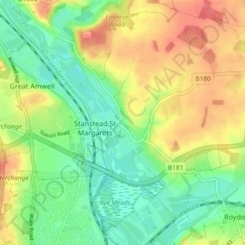
Nom : Carte topographique Stanstead Abbotts, altitude, relief.
Altitude moyenne : 48 m
Altitude minimum : 21 m
Altitude maximum : 81 m
Autres cartes topographiques
Cliquez sur une carte pour visualiser sa topographie, son altitude et son relief.
Hertford Heath
United Kingdom > England > Hertfordshire > East Hertfordshire
Hertford Heath, East Hertfordshire, Hertfordshire, England, United Kingdom
Altitude moyenne : 74 m
Ware
United Kingdom > England > Hertfordshire > East Hertfordshire
Ware, East Hertfordshire, Hertfordshire, England, United Kingdom
Altitude moyenne : 55 m
Bishop's Stortford
United Kingdom > England > Hertfordshire > East Hertfordshire
Bishop's Stortford, East Hertfordshire, Hertfordshire, England, United Kingdom
Altitude moyenne : 83 m