
Faire un don
Équipez-vous pour votre prochaine aventure :
En tant que Partenaire Amazon, ce site perçoit une commission sur les achats éligibles sans surcoût pour vous.
Carte topographique Kanyakumari
Cliquez sur la carte pour afficher l’altitude.
Faire un don
Équipez-vous pour votre prochaine aventure :
En tant que Partenaire Amazon, ce site perçoit une commission sur les achats éligibles sans surcoût pour vous.
Kanyakumari
Kanniyakumari is located at 8°05′N 77°34′E / 8.08°N 77.57°E / 8.08; 77.57. and has an average elevation of 30 metres. The peninsular tip of Kanniyakumari is bordered on three sides by the Laccadive Sea. It is located at the confluence of the Western Coastal Plains and Eastern Coastal Plains.
Faire un don
Équipez-vous pour votre prochaine aventure :
En tant que Partenaire Amazon, ce site perçoit une commission sur les achats éligibles sans surcoût pour vous.
À propos de cette carte
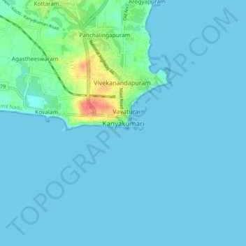
Nom : Carte topographique Kanyakumari, altitude, relief.
Altitude moyenne : 6 m
Altitude minimum : 0 m
Altitude maximum : 55 m
Faire un don
Équipez-vous pour votre prochaine aventure :
En tant que Partenaire Amazon, ce site perçoit une commission sur les achats éligibles sans surcoût pour vous.