
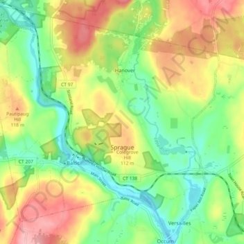
Carte topographique Sprague
Carte interactive
Cliquez sur la carte pour afficher l’altitude.
À propos de cette carte
Nom : Carte topographique Sprague, altitude, relief.
Altitude moyenne : 77 m
Altitude minimum : 18 m
Altitude maximum : 155 m
Autres cartes topographiques
Cliquez sur une carte pour visualiser sa topographie, son altitude et son relief.
Groton
United States > Connecticut > Southeastern Connecticut Planning Region
Groton, Southeastern Connecticut Planning Region, Connecticut, United States
Altitude moyenne : 21 m
New London County
United States > Connecticut > Southeastern Connecticut Planning Region
New London County, Southeastern Connecticut Planning Region, Connecticut, United States
Altitude moyenne : 73 m
Lebanon
United States > Connecticut > Southeastern Connecticut Planning Region
Lebanon, Southeastern Connecticut Planning Region, Connecticut, 06249, United States
Altitude moyenne : 119 m
New London
United States > Connecticut > Southeastern Connecticut Planning Region
New London, Southeastern Connecticut Planning Region, Connecticut, 06320, United States
Altitude moyenne : 17 m
Graniteville
United States > Connecticut > Southeastern Connecticut Planning Region > Waterford
Graniteville, Waterford, Southeastern Connecticut Planning Region, Connecticut, 06385, United States
Altitude moyenne : 22 m
North Stonington
United States > Connecticut > Southeastern Connecticut Planning Region
North Stonington, Southeastern Connecticut Planning Region, Connecticut, 06338, United States
Altitude moyenne : 73 m
Norwich
United States > Connecticut > Southeastern Connecticut Planning Region
Norwich, Southeastern Connecticut Planning Region, Connecticut, United States
Altitude moyenne : 63 m
Franklin
United States > Connecticut > Southeastern Connecticut Planning Region
Franklin, Southeastern Connecticut Planning Region, Connecticut, 06254, United States
Altitude moyenne : 95 m
Sandy Point
United States > Connecticut > Southeastern Connecticut Planning Region > Waterford
Sandy Point, Waterford, Southeastern Connecticut Planning Region, Connecticut, 06357, United States
Altitude moyenne : 26 m
Waterford
United States > Connecticut > Southeastern Connecticut Planning Region
Waterford, Southeastern Connecticut Planning Region, Connecticut, United States
Altitude moyenne : 30 m
East Lyme
United States > Connecticut > Southeastern Connecticut Planning Region
East Lyme, Southeastern Connecticut Planning Region, Connecticut, United States
Altitude moyenne : 41 m
Avery Pond
United States > Connecticut > Southeastern Connecticut Planning Region > Preston
Avery Pond, Preston, Southeastern Connecticut Planning Region, Connecticut, United States
Altitude moyenne : 51 m
Pawcatuck
United States > Connecticut > Southeastern Connecticut Planning Region > Stonington
Pawcatuck, Stonington, Southeastern Connecticut Planning Region, Connecticut, 06379, United States
Altitude moyenne : 26 m
Mystic
United States > Connecticut > Southeastern Connecticut Planning Region > Stonington
Mystic, Stonington, Southeastern Connecticut Planning Region, Connecticut, 06388, United States
Altitude moyenne : 17 m
Niantic
United States > Connecticut > Southeastern Connecticut Planning Region > East Lyme
Niantic, East Lyme, Southeastern Connecticut Planning Region, Connecticut, 06357, United States
Altitude moyenne : 12 m
Baltic
United States > Connecticut > Southeastern Connecticut Planning Region > Sprague
Baltic, Sprague, Southeastern Connecticut Planning Region, Connecticut, United States
Altitude moyenne : 81 m
Central Waterford CDP
United States > Connecticut > Southeastern Connecticut Planning Region > Waterford
Central Waterford CDP, Waterford, Southeastern Connecticut Planning Region, Connecticut, 06385, United States
Altitude moyenne : 22 m
Colchester
United States > Connecticut > Southeastern Connecticut Planning Region
Colchester, Southeastern Connecticut Planning Region, Connecticut, 06415, United States
Altitude moyenne : 134 m
Franklin Park
United States > Connecticut > Southeastern Connecticut Planning Region > Norwich
Franklin Park, Little Plain Historic District, Greeneville, Norwich, Southeastern Connecticut Planning Region, Connecticut, 06360, United States
Altitude moyenne : 39 m
Fort Trumbull State Park
United States > Connecticut > Southeastern Connecticut Planning Region > New London
Fort Trumbull State Park, Downtown New London, New London, Southeastern Connecticut Planning Region, Connecticut, 06320, United States
Altitude moyenne : 12 m
Crescent Beach
United States > Connecticut > Southeastern Connecticut Planning Region > East Lyme > Niantic
Crescent Beach, Niantic, East Lyme, Southeastern Connecticut Planning Region, Connecticut, 06357, United States
Altitude moyenne : 9 m
Avon Place/Fieldcrest Play Area
United States > Connecticut > Southeastern Connecticut Planning Region > Groton > Old Mystic
Avon Place/Fieldcrest Play Area, Burnett's Corner Historic District, Old Mystic, Groton, Southeastern Connecticut Planning Region, Connecticut, United States
Altitude moyenne : 36 m
Prospect Hill
United States > Connecticut > Southeastern Connecticut Planning Region > New London
Prospect Hill, New London, Southeastern Connecticut Planning Region, Connecticut, 06385, United States
Altitude moyenne : 38 m
Niantic
United States > Connecticut > Southeastern Connecticut Planning Region > East Lyme > Niantic
Niantic, East Lyme, Southeastern Connecticut Planning Region, Connecticut, United States
Altitude moyenne : 12 m
Gales Ferry
United States > Connecticut > Southeastern Connecticut Planning Region > Ledyard > Gales Ferry
Gales Ferry, Ledyard, Southeastern Connecticut Planning Region, Connecticut, United States
Altitude moyenne : 24 m
Montville
United States > Connecticut > Southeastern Connecticut Planning Region
Montville, Southeastern Connecticut Planning Region, Connecticut, United States
Altitude moyenne : 80 m
Uncasville
United States > Connecticut > Southeastern Connecticut Planning Region > Montville
Uncasville, Montville, Southeastern Connecticut Planning Region, Connecticut, 06382, United States
Altitude moyenne : 40 m
Stonington
United States > Connecticut > Southeastern Connecticut Planning Region
Stonington, Southeastern Connecticut Planning Region, Connecticut, United States
Altitude moyenne : 25 m
Salem
United States > Connecticut > Southeastern Connecticut Planning Region
Salem, Southeastern Connecticut Planning Region, Connecticut, 06420, United States
Altitude moyenne : 119 m
Willimantic
United States > Connecticut > Southeastern Connecticut Planning Region
Willimantic, Windham, Southeastern Connecticut Planning Region, Connecticut, 06226, United States
Altitude moyenne : 103 m