
Carte topographique Sullivan County
Carte interactive
Cliquez sur la carte pour afficher l’altitude.
À propos de cette carte
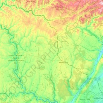
Nom : Carte topographique Sullivan County, altitude, relief.
Lieu : Sullivan County, New York, United States of America (41.42166 -75.14682 42.01666 -74.36433)
Altitude moyenne : 435 m
Altitude minimum : 98 m
Altitude maximum : 1.259 m
Autres cartes topographiques
Cliquez sur une carte pour visualiser sa topographie, son altitude et son relief.
Yaphank
United States of America > New York > Yaphank
Yaphank, Suffolk, New York, 11980, United States of America
Altitude moyenne : 24 m
Saratoga County
United States of America > New York
Saratoga County, New York, United States of America
Altitude moyenne : 218 m
Westchester
United States of America > New York
Westchester, New York, United States of America
Altitude moyenne : 95 m
Essex County
United States of America > New York
Essex County, New York, United States of America
Altitude moyenne : 418 m
Farmingville
United States of America > New York > Farmingville
Farmingville, Suffolk, New York, 11738, United States of America
Altitude moyenne : 47 m
Honeymoon Island
United States of America > New York
Honeymoon Island, Franklin County, New York, United States of America
Altitude moyenne : 489 m
Riverhead
United States of America > New York > Riverhead
Riverhead, Suffolk County, New York, United States of America
Altitude moyenne : 13 m
Syracuse
United States of America > New York > Syracuse
Syracuse, Onondaga County, New York, United States of America
Altitude moyenne : 172 m
Barrytown
United States of America > New York > Barrytown
Barrytown, Town of Red Hook, Dutchess, New York, 12507, United States of America
Altitude moyenne : 34 m
Chenango County
United States of America > New York
Chenango County, New York, United States of America
Altitude moyenne : 442 m
Niagara County
United States of America > New York
Niagara County, New York, United States of America
Altitude moyenne : 137 m
Saint Lawrence County
United States of America > New York
Saint Lawrence County, New York, United States of America
Altitude moyenne : 239 m
Nassau County
United States of America > New York
Nassau County, New York, United States of America
Altitude moyenne : 18 m
Niagara Falls
United States of America > New York > Niagara Falls
Niagara Falls, Niagara County, New York, United States of America
Altitude moyenne : 180 m