
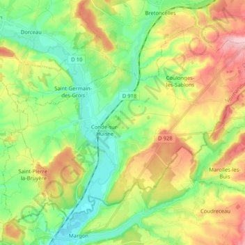
Carte topographique Sablons sur Huisne
Carte interactive
Cliquez sur la carte pour afficher l’altitude.
À propos de cette carte
Nom : Carte topographique Sablons sur Huisne, altitude, relief.
Altitude moyenne : 167 m
Altitude minimum : 103 m
Altitude maximum : 265 m
Autres cartes topographiques
Cliquez sur une carte pour visualiser sa topographie, son altitude et son relief.
Champsecret
Champsecret, Argentan, Orne, Normandie, France métropolitaine, 61700, France
Altitude moyenne : 215 m
Moulicent
France > Normandie > Orne > Longny les Villages
Moulicent, Longny les Villages, Mortagne-au-Perche, Orne, Normandie, France métropolitaine, 61290, France
Altitude moyenne : 219 m
Fresnay-le-Samson
Fresnay-le-Samson, Mortagne-au-Perche, Orne, Normandie, France métropolitaine, 61120, France
Altitude moyenne : 187 m
Fort Fresnay
France > Normandie > Orne > Fresnay-le-Samson
Fort Fresnay, D 242, Fresnay-le-Samson, Mortagne-au-Perche, Orne, Normandie, France métropolitaine, 61120, France
Altitude moyenne : 175 m
Les Gastineaux
France > Normandie > Orne > Soligny-la-Trappe
Les Gastineaux, Soligny-la-Trappe, Mortagne-au-Perche, Orne, Normandie, France métropolitaine, 61380, France
Altitude moyenne : 258 m
Marchainville
France > Normandie > Orne > Longny les Villages
Marchainville, Longny les Villages, Mortagne-au-Perche, Orne, Normandie, France métropolitaine, 61290, France
Altitude moyenne : 246 m
La Saussaie
France > Normandie > Orne > Bretoncelles
La Saussaie, Bretoncelles, Mortagne-au-Perche, Orne, Normandie, France métropolitaine, 61110, France
Altitude moyenne : 161 m
Glos-la-Ferrière
France > Normandie > Orne > La Ferté-en-Ouche
Glos-la-Ferrière, La Ferté-en-Ouche, Mortagne-au-Perche, Orne, Normandie, France métropolitaine, 61550, France
Altitude moyenne : 239 m
La Trinité-des-Laitiers
La Trinité-des-Laitiers, Mortagne-au-Perche, Orne, Normandie, France métropolitaine, 61230, France
Altitude moyenne : 290 m
Rémalard
France > Normandie > Orne > Rémalard en Perche
Rémalard, Rémalard en Perche, Mortagne-au-Perche, Orne, Normandie, France métropolitaine, 61110, France
Altitude moyenne : 177 m
Courteille
France > Normandie > Orne > Suré
Courteille, Suré, Mortagne-au-Perche, Orne, Normandie, France métropolitaine, 61360, France
Altitude moyenne : 153 m
Les Champeaux
Les Champeaux, Mortagne-au-Perche, Orne, Normandie, France métropolitaine, 61120, France
Altitude moyenne : 210 m
Mâle
France > Normandie > Orne > Val-au-Perche
Mâle, Val-au-Perche, Mortagne-au-Perche, Orne, Normandie, France métropolitaine, 61260, France
Altitude moyenne : 149 m
61110
France > Normandie > Orne > Rémalard en Perche > La Guénetterie
61110, La Guénetterie, Dorceau, Rémalard en Perche, Mortagne-au-Perche, Orne, Normandie, France métropolitaine, France
Altitude moyenne : 159 m
Saint-Georges-des-Groseillers
Saint-Georges-des-Groseillers, Argentan, Orne, Normandie, France métropolitaine, 61100, France
Altitude moyenne : 210 m
La Lande-de-Goult
La Lande-de-Goult, Alençon, Orne, Normandie, France métropolitaine, 61320, France
Altitude moyenne : 334 m
La Maillardière
France > Normandie > Orne > Montilly-sur-Noireau
La Maillardière, Montilly-sur-Noireau, Argentan, Orne, Normandie, France métropolitaine, 61100, France
Altitude moyenne : 128 m
Le Grand Samoi
France > Normandie > Orne > Saint-Pierre-du-Regard
Le Grand Samoi, Saint-Pierre-du-Regard, Argentan, Orne, Normandie, France métropolitaine, 61790, France
Altitude moyenne : 139 m
Le Pin-au-Haras
Le Pin-au-Haras, Argentan, Orne, Normandie, France métropolitaine, 61310, France
Altitude moyenne : 194 m
Montilly-sur-Noireau
Montilly-sur-Noireau, Argentan, Orne, Normandie, France métropolitaine, 61100, France
Altitude moyenne : 158 m
Le bois Hodet
France > Normandie > Orne > Saint-Bômer-les-Forges
Le bois Hodet, Saint-Bômer-les-Forges, Argentan, Orne, Normandie, France métropolitaine, 61700, France
Altitude moyenne : 216 m
Le Val Héroult
France > Normandie > Orne > Ménil-Hubert-en-Exmes
Le Val Héroult, Ménil-Hubert-en-Exmes, Mortagne-au-Perche, Orne, Normandie, France métropolitaine, 61230, France
Altitude moyenne : 261 m
Orgeuil
France > Normandie > Orne > Ferrières-la-Verrerie
Orgeuil, Ferrières-la-Verrerie, Alençon, Orne, Normandie, France métropolitaine, 61390, France
Altitude moyenne : 217 m
Nonant-le-Pin
Nonant-le-Pin, Mortagne-au-Perche, Orne, Normandie, France métropolitaine, 61240, France
Altitude moyenne : 206 m
Le Bourg-Saint-Léonard
France > Normandie > Orne > Gouffern en Auge
Le Bourg-Saint-Léonard, Gouffern en Auge, Argentan, Orne, Normandie, France métropolitaine, 61310, France
Altitude moyenne : 168 m
Putanges-Pont-Écrepin
France > Normandie > Orne > Putanges-le-Lac
Putanges-Pont-Écrepin, Putanges-le-Lac, Argentan, Orne, Normandie, France métropolitaine, 61210, France
Altitude moyenne : 186 m
Le Mêle-sur-Sarthe
Le Mêle-sur-Sarthe, Alençon, Orne, Normandie, France métropolitaine, 61170, France
Altitude moyenne : 154 m
La Pêcherie
France > Normandie > Orne > Courgeon
La Pêcherie, Courgeon, Mortagne-au-Perche, Orne, Normandie, France métropolitaine, 61400, France
Altitude moyenne : 164 m
La Perrotière
France > Normandie > Orne > La Chapelle-Viel
La Perrotière, La Chapelle-Viel, Mortagne-au-Perche, Orne, Normandie, France métropolitaine, 61270, France
Altitude moyenne : 251 m
Le Cauche de la Sapaie
France > Normandie > Orne > Saint-Symphorien-des-Bruyères
Le Cauche de la Sapaie, Saint-Symphorien-des-Bruyères, Mortagne-au-Perche, Orne, Normandie, France métropolitaine, 61300, France
Altitude moyenne : 258 m
Juvigny-sous-Andaine
France > Normandie > Orne > Juvigny-Val-d'Andaine
Juvigny-sous-Andaine, Juvigny-Val-d'Andaine, Alençon, Orne, Normandie, France métropolitaine, 61140, France
Altitude moyenne : 185 m
Le Ray
France > Normandie > Orne > Putanges-le-Lac > La Forêt-Auvray
Le Ray, La Forêt-Auvray, Putanges-le-Lac, Argentan, Orne, Normandie, France métropolitaine, 61210, France
Altitude moyenne : 164 m
Neauphe-sur-Dive
Neauphe-sur-Dive, Argentan, Orne, Normandie, France métropolitaine, 61160, France
Altitude moyenne : 120 m
Saint-Philbert-sur-Orne
Saint-Philbert-sur-Orne, Argentan, Orne, Normandie, France métropolitaine, 61430, France
Altitude moyenne : 113 m
La Taille
France > Normandie > Orne > Val-au-Perche
La Taille, Le Theil, Val-au-Perche, Mortagne-au-Perche, Orne, Normandie, France métropolitaine, 61260, France
Altitude moyenne : 123 m
Longny-au-Perche
France > Normandie > Orne > Longny les Villages
Longny-au-Perche, Longny les Villages, Mortagne-au-Perche, Orne, Normandie, France métropolitaine, 61290, France
Altitude moyenne : 207 m
Saint Germain-De-Loisé
France > Normandie > Orne > Mortagne-au-Perche
Saint Germain-De-Loisé, Mortagne-au-Perche, Orne, Normandie, France métropolitaine, 61400, France
Altitude moyenne : 210 m
La Moisière
France > Normandie > Orne > Bonsmoulins
La Moisière, Bonsmoulins, Mortagne-au-Perche, Orne, Normandie, France métropolitaine, 61380, France
Altitude moyenne : 250 m
Boissy-Maugis
France > Normandie > Orne > Cour-Maugis sur Huisne
Boissy-Maugis, Cour-Maugis sur Huisne, Mortagne-au-Perche, Orne, Normandie, France métropolitaine, 61110, France
Altitude moyenne : 184 m
Neuville-près-Sées
Neuville-près-Sées, Chailloué, Alençon, Orne, Normandie, France métropolitaine, 61500, France
Altitude moyenne : 197 m
Soligny-la-Trappe
Soligny-la-Trappe, Mortagne-au-Perche, Orne, Normandie, France métropolitaine, 61380, France
Altitude moyenne : 250 m