
Carte topographique Menifee County
Carte interactive
Cliquez sur la carte pour afficher l’altitude.
À propos de cette carte
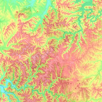
Nom : Carte topographique Menifee County, altitude, relief.
Lieu : Menifee County, Kentucky, VS (37.81840 -83.77553 38.05887 -83.43369)
Altitude moyenne : 313 m
Altitude minimum : 199 m
Altitude maximum : 424 m
Autres cartes topographiques
Cliquez sur une carte pour visualiser sa topographie, son altitude et son relief.
Hodgenville
VS > Kentucky > Hodgenville
Hodgenville, Larue County, Kentucky, VS
Altitude moyenne : 229 m
Nationaal park Mammoth Cave
VS > Kentucky > Mammoth Cave
Nationaal park Mammoth Cave, Green River Ferry Road, Mammoth Cave, Edmonson County, Kentucky, VS
Altitude moyenne : 215 m
Abraham Lincoln Birthplace National Historic Site
VS > Kentucky > Boundary Oak
Abraham Lincoln Birthplace National Historic Site, Boundary Oak, Larue County, Kentucky, VS
Altitude moyenne : 238 m
The Meadow
VS > Kentucky > The Meadow
The Meadow, Jefferson County, Kentucky, 40242, VS
Altitude moyenne : 200 m