
Faire un don
Équipez-vous pour votre prochaine aventure :
En tant que Partenaire Amazon, ce site perçoit une commission sur les achats éligibles sans surcoût pour vous.
Carte topographique McKenzie Bridge
Cliquez sur la carte pour afficher l’altitude.
Faire un don
Équipez-vous pour votre prochaine aventure :
En tant que Partenaire Amazon, ce site perçoit une commission sur les achats éligibles sans surcoût pour vous.
À propos de cette carte
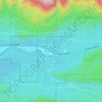
Nom : Carte topographique McKenzie Bridge, altitude, relief.
Lieu : McKenzie Bridge, Lane County, Oregon, 97413, United States (44.15482 -122.18331 44.19482 -122.14331)
Altitude moyenne : 521 m
Altitude minimum : 390 m
Altitude maximum : 1.076 m
Faire un don
Équipez-vous pour votre prochaine aventure :
En tant que Partenaire Amazon, ce site perçoit une commission sur les achats éligibles sans surcoût pour vous.
Autres cartes topographiques
Cliquez sur une carte pour visualiser sa topographie, son altitude et son relief.
Eugene
United States > Oregon > Lane County
Eugene is characterized by a varied topography that contributes to its picturesque landscapes. The city sits at an average elevation of about 426 feet (130 meters) and is nestled within the Willamette Valley, surrounded by the foothills of the Cascade Mountains to the east, which rise significantly in…
Altitude moyenne : 163 m
Thurston Hills Natural Area
United States > Oregon > Lane County > Springfield
Altitude moyenne : 324 m
Faire un don
Équipez-vous pour votre prochaine aventure :
En tant que Partenaire Amazon, ce site perçoit une commission sur les achats éligibles sans surcoût pour vous.
Lowell
United States > Oregon > Lane County
The climate of Lowell differs slightly from that of Eugene, which is at lower elevation. Lowell receives 8 inches (20 cm) more of rain and 2 inches (51 mm) more of snow per year than Eugene. In central Lane County, that two inches is significant considering the lack of snow. The higher areas of the town…
Altitude moyenne : 261 m
Faire un don
Équipez-vous pour votre prochaine aventure :
En tant que Partenaire Amazon, ce site perçoit une commission sur les achats éligibles sans surcoût pour vous.
Oakridge
United States > Oregon > Lane County
The city was originally a community called "Hazeldell", and its post office was established on July 26, 1888. When a station on the Southern Pacific Railroad opened in May 1912, it was named "Oak Ridge" by a railroad executive for the surrounding topography, and on July 19 of that year the name was changed to…
Altitude moyenne : 465 m
Faire un don
Équipez-vous pour votre prochaine aventure :
En tant que Partenaire Amazon, ce site perçoit une commission sur les achats éligibles sans surcoût pour vous.
Eugene
United States > Oregon > Lane County
According to the United States Census Bureau, the city has a total area of 43.74 square miles (113.29 km2), of which 43.72 square miles (113.23 km2) is land and 0.02 square miles (0.05 km2) is water. Eugene is at an elevation of 426 feet (130 m).
Altitude moyenne : 163 m
Faire un don
Équipez-vous pour votre prochaine aventure :
En tant que Partenaire Amazon, ce site perçoit une commission sur les achats éligibles sans surcoût pour vous.
Eugene
United States > Oregon > Lane County
According to the United States Census Bureau, the city has a total area of 43.74 square miles (113.29 km2), of which 43.72 square miles (113.23 km2) is land and 0.02 square miles (0.05 km2) is water. Eugene is at an elevation of 426 feet (130 m).
Altitude moyenne : 163 m
Oakridge
United States > Oregon > Lane County
The city was originally a community called "Hazeldell", and its post office was established on July 26, 1888. When a station on the Southern Pacific Railroad opened in May 1912, it was named "Oak Ridge" by a railroad executive for the surrounding topography, and on July 19 of that year the name was changed to…
Altitude moyenne : 465 m
Faire un don
Équipez-vous pour votre prochaine aventure :
En tant que Partenaire Amazon, ce site perçoit une commission sur les achats éligibles sans surcoût pour vous.
Eugene
United States > Oregon > Lane County
According to the United States Census Bureau, the city has a total area of 43.74 square miles (113.29 km2), of which 43.72 square miles (113.23 km2) is land and 0.02 square miles (0.05 km2) is water. Eugene is at an elevation of 426 feet (130 m).
Altitude moyenne : 163 m
Faire un don
Équipez-vous pour votre prochaine aventure :
En tant que Partenaire Amazon, ce site perçoit une commission sur les achats éligibles sans surcoût pour vous.
Faire un don
Équipez-vous pour votre prochaine aventure :
En tant que Partenaire Amazon, ce site perçoit une commission sur les achats éligibles sans surcoût pour vous.
Eugene
United States > Oregon > Lane County
According to the United States Census Bureau, the city has a total area of 43.74 square miles (113.29 km2), of which 43.72 square miles (113.23 km2) is land and 0.02 square miles (0.05 km2) is water. Eugene is at an elevation of 426 feet (130 m).
Altitude moyenne : 163 m
Faire un don
Équipez-vous pour votre prochaine aventure :
En tant que Partenaire Amazon, ce site perçoit une commission sur les achats éligibles sans surcoût pour vous.
Oakridge
United States > Oregon > Lane County
The city was originally a community called "Hazeldell", and its post office was established on July 26, 1888. When a station on the Southern Pacific Railroad opened in May 1912, it was named "Oak Ridge" by a railroad executive for the surrounding topography, and on July 19 of that year the name was changed to…
Altitude moyenne : 465 m