
Faire un don
Équipez-vous pour votre prochaine aventure :
En tant que Partenaire Amazon, ce site perçoit une commission sur les achats éligibles sans surcoût pour vous.
Carte topographique Kabacan
Cliquez sur la carte pour afficher l’altitude.
Faire un don
Équipez-vous pour votre prochaine aventure :
En tant que Partenaire Amazon, ce site perçoit une commission sur les achats éligibles sans surcoût pour vous.
Kabacan
The landscape is characterized by almost regular landscape of flat terrain. The high mountains and rolling hills leaping close to the river plus the narrow plains have varied topographical features. Other features are moderately sloping and strongly sloping.
Faire un don
Équipez-vous pour votre prochaine aventure :
En tant que Partenaire Amazon, ce site perçoit une commission sur les achats éligibles sans surcoût pour vous.
À propos de cette carte
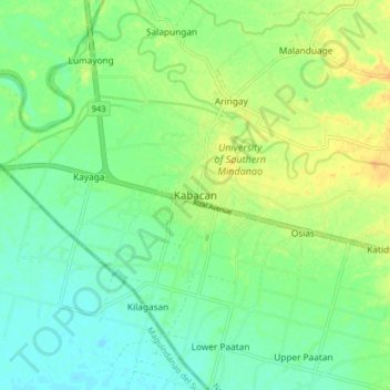
Nom : Carte topographique Kabacan, altitude, relief.
Lieu : Kabacan, North Cotabato, Soccsksargen, 9407, Philippines (7.06923 124.78450 7.14923 124.86450)
Altitude moyenne : 21 m
Altitude minimum : 9 m
Altitude maximum : 36 m
Faire un don
Équipez-vous pour votre prochaine aventure :
En tant que Partenaire Amazon, ce site perçoit une commission sur les achats éligibles sans surcoût pour vous.
Autres cartes topographiques
Cliquez sur une carte pour visualiser sa topographie, son altitude et son relief.
Faire un don
Équipez-vous pour votre prochaine aventure :
En tant que Partenaire Amazon, ce site perçoit une commission sur les achats éligibles sans surcoût pour vous.
Kidapawan
Located in Kidapawan is the Paniki Falls Eco-River Park located at Umpan Village, Barangay Balabag. Kidapawan is also one of the most well-known starting points for trekking on Mount Apo via the city's Lake Agco in Barangay Ilomavis, Kidapawan-Santa Cruz, and Kidapawan-Magpet trails which towers at 10,311 feet…
Altitude moyenne : 494 m