
Carte topographique Blonay
Carte interactive
Cliquez sur la carte pour afficher l’altitude.
À propos de cette carte
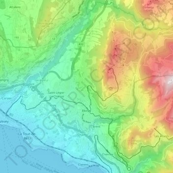
Nom : Carte topographique Blonay, altitude, relief.
Altitude moyenne : 885 m
Altitude minimum : 367 m
Altitude maximum : 1.733 m
Blonay overlooks Lake Geneva, with the hill 'Les Pléiades' behind the town. The municipality stretches from an elevation of about 500 to 1,400 m (1,600 to 4,600 ft). It consists of the village of Blonay with the sections of Tercier and Cojonnex and a number of hamlets including Les Chevalleyres.
Autres cartes topographiques
Cliquez sur une carte pour visualiser sa topographie, son altitude et son relief.
Veveyse
Switzerland > Vaud > District de la Riviera-Pays-d’Enhaut > Blonay - Saint-Légier
Veveyse, Blonay - Saint-Légier, District de la Riviera-Pays-d’Enhaut, Vaud, 1809, Switzerland
Altitude moyenne : 742 m