
Carte topographique Gresham
Carte interactive
Cliquez sur la carte pour afficher l’altitude.
À propos de cette carte
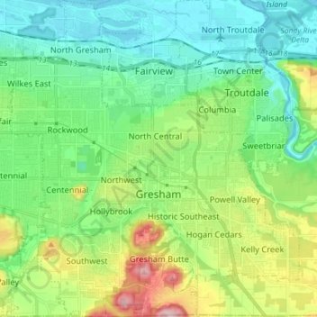
Nom : Carte topographique Gresham, altitude, relief.
Lieu : Gresham, Multnomah County, Oregon, United States (45.46094 -122.49807 45.56088 -122.36758)
Altitude moyenne : 90 m
Altitude minimum : -2 m
Altitude maximum : 322 m
Though much of Gresham is relatively flat, it is characterized by a hill on its eastern border. Northeast Gresham is also hilly, particularly where the city meets Troutdale toward the Columbia River. Its elevation is 325 feet (99 m). Johnson Creek, which begins at the foothills of the Cascade Mountains, runs westward through Gresham, with 23 percent of the creek's watershed running through the city.
Autres cartes topographiques
Cliquez sur une carte pour visualiser sa topographie, son altitude et son relief.
Portland
United States > Oregon > Multnomah County
Portland, Multnomah County, Oregon, United States
Altitude moyenne : 77 m
Corbett
United States > Oregon > Multnomah County
Corbett, Multnomah County, Oregon, 97019, United States
Altitude moyenne : 127 m
Sauvie Island
United States > Oregon > Multnomah County
Sauvie Island, Multnomah County, Oregon, United States
Altitude moyenne : 157 m
Troutdale
United States > Oregon > Multnomah County
Troutdale, Multnomah County, Oregon, 97060, United States
Altitude moyenne : 54 m
Pearl District
United States > Oregon > Multnomah County > Portland
Pearl District, Portland, Multnomah County, Oregon, United States
Altitude moyenne : 25 m
East Columbia
United States > Oregon > Multnomah County > Portland
East Columbia, Portland, Multnomah County, Oregon, United States
Altitude moyenne : 9 m