
Faire un don
Équipez-vous pour votre prochaine aventure :
En tant que Partenaire Amazon, ce site perçoit une commission sur les achats éligibles sans surcoût pour vous.
Carte topographique Denton
Cliquez sur la carte pour afficher l’altitude.
Faire un don
Équipez-vous pour votre prochaine aventure :
En tant que Partenaire Amazon, ce site perçoit une commission sur les achats éligibles sans surcoût pour vous.
Denton
Denton is on the northern edge of the Dallas–Fort Worth metropolitan area. These three cities form the area known as the "Golden Triangle of North Texas". According to the United States Census Bureau, the city has an area of 89.316 square miles (231.33 km2), of which 87.952 square miles (227.79 km2) is land and 1.364 square miles (3.53 km2) is covered by water. The city lies in the northeast edge of the Bend Arch–Fort Worth Basin, which is characterized by flat terrain. Elevation ranges from 500 to 900 feet (150 to 270 m). Part of the city is atop the Barnett Shale, a geological formation believed to contain large quantities of natural gas. Lewisville Lake, a man-made reservoir, is 15 miles (24 km) south of the city.
Faire un don
Équipez-vous pour votre prochaine aventure :
En tant que Partenaire Amazon, ce site perçoit une commission sur les achats éligibles sans surcoût pour vous.
À propos de cette carte
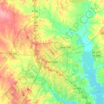
Nom : Carte topographique Denton, altitude, relief.
Lieu : Denton, Denton County, Texas, United States (33.11749 -97.26651 33.35824 -97.02394)
Altitude moyenne : 195 m
Altitude minimum : 155 m
Altitude maximum : 255 m
Faire un don
Équipez-vous pour votre prochaine aventure :
En tant que Partenaire Amazon, ce site perçoit une commission sur les achats éligibles sans surcoût pour vous.