
Faire un don
Équipez-vous pour votre prochaine aventure :
En tant que Partenaire Amazon, ce site perçoit une commission sur les achats éligibles sans surcoût pour vous.
Carte topographique Kollegala taluk
Cliquez sur la carte pour afficher l’altitude.
Faire un don
Équipez-vous pour votre prochaine aventure :
En tant que Partenaire Amazon, ce site perçoit une commission sur les achats éligibles sans surcoût pour vous.
À propos de cette carte
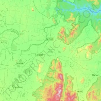
Nom : Carte topographique Kollegala taluk, altitude, relief.
Lieu : Kollegala taluk, Chamarajanagar, Karnataka, India (12.02992 76.96891 12.31052 77.32010)
Altitude moyenne : 683 m
Altitude minimum : 385 m
Altitude maximum : 1.475 m
Faire un don
Équipez-vous pour votre prochaine aventure :
En tant que Partenaire Amazon, ce site perçoit une commission sur les achats éligibles sans surcoût pour vous.
Autres cartes topographiques
Cliquez sur une carte pour visualiser sa topographie, son altitude et son relief.
Mangaluru
India > Karnataka > Mangaluru taluk
Mangalore is also the administrative headquarters of the Dakshina Kannada district; it is a commercial, industrial, educational, healthcare, and startup hub. The city's international airport is the second-largest and second-busiest airport in Karnataka. Mangalore City Corporation is responsible for the civic…
Altitude moyenne : 25 m
Faire un don
Équipez-vous pour votre prochaine aventure :
En tant que Partenaire Amazon, ce site perçoit une commission sur les achats éligibles sans surcoût pour vous.
Mysuru
India > Karnataka > Mysuru taluk
Mysore (/maɪˈsɔːr/ (listen)), officially Mysuru ([ˈmaɪˈsuːɾu] (listen)), is a city in the southern part of the state of Karnataka, India. Mysore city is geographically located between 12° 18′ 26″ north latitude and 76° 38′ 59″ east longitude. It is located at an altitude of 770 m (2,530 ft)…
Altitude moyenne : 727 m
Faire un don
Équipez-vous pour votre prochaine aventure :
En tant que Partenaire Amazon, ce site perçoit une commission sur les achats éligibles sans surcoût pour vous.
Dakshina Kannada
The topography of the district is plain up to 30 km (18.64 mi) inside the coast and changes to undulating hilly terrain sharply towards the east in the Western Ghats. Teak, bamboo and rosewood trees are found in the hilly areas towards the east. The Geological Survey of India has identified this district as a…
Altitude moyenne : 109 m
Harapanahalli
India > Karnataka > Harapanahalli taluku
It has an average elevation of 633 metres (2,077 ft) above the Mean sea level. Harapanahalli is surrounded by several districts like Davanagere in the South, Chithradurga in the Southeast, Haveri in the West.
Altitude moyenne : 626 m
Sira
India > Karnataka > Sira taluk
Sira is located at 13°45′N 76°55′E / 13.75°N 76.91°E / 13.75; 76.91. It has an average elevation of 662 metres (2171 feet).
Altitude moyenne : 655 m
Faire un don
Équipez-vous pour votre prochaine aventure :
En tant que Partenaire Amazon, ce site perçoit une commission sur les achats éligibles sans surcoût pour vous.
Gundlupet
India > Karnataka > Gundlupet taluk
Gundlupet is located at 11°48′N 76°41′E / 11.8°N 76.68°E / 11.8; 76.68. It has an average elevation of 816 metres (2,677 feet).
Altitude moyenne : 807 m
Faire un don
Équipez-vous pour votre prochaine aventure :
En tant que Partenaire Amazon, ce site perçoit une commission sur les achats éligibles sans surcoût pour vous.
Sirsi
India > Karnataka > Shirasi taluk
Sirsi is located at 14°37′N 74°51′E / 14.62°N 74.85°E / 14.62; 74.85 (Grid Square MK74).[3] It has an elevation ranging between 1860 feet to 2600 feet above sea level, and is situated in the heart of the Western Ghats. Sirsi is about 399 kilometres (248 mi) from Bangalore. The nearest airport…
Altitude moyenne : 556 m
Faire un don
Équipez-vous pour votre prochaine aventure :
En tant que Partenaire Amazon, ce site perçoit une commission sur les achats éligibles sans surcoût pour vous.
Faire un don
Équipez-vous pour votre prochaine aventure :
En tant que Partenaire Amazon, ce site perçoit une commission sur les achats éligibles sans surcoût pour vous.
Bagalkote
India > Karnataka > Bagalakote taluk
Bagalkote, is a city in the state of Karnataka, India, which is also the headquarters of Bagalkot district. It is situated on branch of River Ghataprabha, The population of the urban agglomeration was 111,933 according to the provisional results of 2011 national census of India, the city is spread over an area…
Altitude moyenne : 556 m
Kalaburagi
India > Karnataka > Kalaburagi taluku
The entire district is on the Deccan Plateau, and the elevation ranges from 300 to 750 m above MSL. Two main rivers, the Krishna and Bhima, flow through the district. The predominant soil type is black soil. The district has many tanks, which irrigate the land along with the river. The Upper Krishna Project is…
Altitude moyenne : 465 m
Faire un don
Équipez-vous pour votre prochaine aventure :
En tant que Partenaire Amazon, ce site perçoit une commission sur les achats éligibles sans surcoût pour vous.
Manipal
India > Karnataka > Udupi taluku
Manipal is a suburb and university town within Udupi, in coastal Karnataka, India. Manipal is located five kilometres away from the centre of Udupi City, in Udupi District, Karnataka (state) in south western India. It is administered by the Udupi City Municipality. The suburb is located in coastal Karnataka,…
Altitude moyenne : 32 m
Udupi
India > Karnataka > Udupi taluku
Udupi has an elevation of 27 m (89 ft) above mean sea level. The climate in Udupi is hot in summers and pleasant in winter. During summers (from March to May) the temperature reaches up to 38 °C (100 °F) and in winters (from December to February) it is usually between 32 and 20 °C (90 and 68 °F). As it is…
Altitude moyenne : 17 m
Faire un don
Équipez-vous pour votre prochaine aventure :
En tant que Partenaire Amazon, ce site perçoit une commission sur les achats éligibles sans surcoût pour vous.
Faire un don
Équipez-vous pour votre prochaine aventure :
En tant que Partenaire Amazon, ce site perçoit une commission sur les achats éligibles sans surcoût pour vous.
Chikkanayakanahalli
India > Karnataka > Chikkanayakanahalli taluk
Chikkanayakana-halli is located at 13°25′N 76°37′E / 13.42°N 76.62°E / 13.42; 76.62. It has an average elevation of 804 metres (2,638 ft). It is located on National Highway 150A.
Altitude moyenne : 811 m
Faire un don
Équipez-vous pour votre prochaine aventure :
En tant que Partenaire Amazon, ce site perçoit une commission sur les achats éligibles sans surcoût pour vous.
Faire un don
Équipez-vous pour votre prochaine aventure :
En tant que Partenaire Amazon, ce site perçoit une commission sur les achats éligibles sans surcoût pour vous.
Faire un don
Équipez-vous pour votre prochaine aventure :
En tant que Partenaire Amazon, ce site perçoit une commission sur les achats éligibles sans surcoût pour vous.
Faire un don
Équipez-vous pour votre prochaine aventure :
En tant que Partenaire Amazon, ce site perçoit une commission sur les achats éligibles sans surcoût pour vous.
Faire un don
Équipez-vous pour votre prochaine aventure :
En tant que Partenaire Amazon, ce site perçoit une commission sur les achats éligibles sans surcoût pour vous.
Faire un don
Équipez-vous pour votre prochaine aventure :
En tant que Partenaire Amazon, ce site perçoit une commission sur les achats éligibles sans surcoût pour vous.
Sanduru
India > Karnataka > Sanduru taluk
Sanduru is located at 15°06′N 76°33′E / 15.1°N 76.55°E / 15.1; 76.55. It has an average elevation of 565 metres (1853 feet).
Altitude moyenne : 647 m
Ullal
India > Karnataka > Ullala taluk
Ullal is located at 12°48′N 74°51′E / 12.8°N 74.85°E / 12.8; 74.85. It has an average elevation of 5 metres (16 ft).
Altitude moyenne : 10 m
Faire un don
Équipez-vous pour votre prochaine aventure :
En tant que Partenaire Amazon, ce site perçoit une commission sur les achats éligibles sans surcoût pour vous.
Srinivaspur
India > Karnataka > Srinivasapura taluku
Srinivaspur is located at 13°20′N 78°13′E / 13.33°N 78.22°E / 13.33; 78.22. It has an average elevation of 819 metres (2,687 ft). The geographical area of the taluk is 860 square kilometres (330 sq mi).
Altitude moyenne : 830 m
Faire un don
Équipez-vous pour votre prochaine aventure :
En tant que Partenaire Amazon, ce site perçoit une commission sur les achats éligibles sans surcoût pour vous.
Kalaghatagi
India > Karnataka > Kalaghatagi taluku
Kalghatgi is located at 15°11′N 74°58′E / 15.18°N 74.97°E / 15.18; 74.97. It has an average elevation of 536 metres (1758 feet). Kalghatgi is located 28 km from Hubli and 30 km from Dharwad.The Kalghatgi town is located on National Highway 63 (India) en route from Hubli to Ankola.
Altitude moyenne : 545 m
Faire un don
Équipez-vous pour votre prochaine aventure :
En tant que Partenaire Amazon, ce site perçoit une commission sur les achats éligibles sans surcoût pour vous.
Aurada
India > Karnataka > Aurad taluku
Aurad is located at 18°15′N 77°26′E / 18.25°N 77.43°E / 18.25; 77.43. It has an average elevation of 542 metres (1,778 ft). Aurad is 840 kilometres (520 mi) from Bengaluru and 42 kilometres (26 mi) from District Headquarters Bidar. The area of Aurad taluka is 1,227.20 km2 having 6 circles, 149…
Altitude moyenne : 553 m
Faire un don
Équipez-vous pour votre prochaine aventure :
En tant que Partenaire Amazon, ce site perçoit une commission sur les achats éligibles sans surcoût pour vous.
Faire un don
Équipez-vous pour votre prochaine aventure :
En tant que Partenaire Amazon, ce site perçoit une commission sur les achats éligibles sans surcoût pour vous.
Faire un don
Équipez-vous pour votre prochaine aventure :
En tant que Partenaire Amazon, ce site perçoit une commission sur les achats éligibles sans surcoût pour vous.
Channagiri
India > Karnataka > Channagiri taluku
Channagiri is located at 14°02′N 75°56′E / 14.03°N 75.93°E / 14.03; 75.93. It has an average elevation of 662 metres (2171 feet).
Altitude moyenne : 679 m
Faire un don
Équipez-vous pour votre prochaine aventure :
En tant que Partenaire Amazon, ce site perçoit une commission sur les achats éligibles sans surcoût pour vous.
Faire un don
Équipez-vous pour votre prochaine aventure :
En tant que Partenaire Amazon, ce site perçoit une commission sur les achats éligibles sans surcoût pour vous.
Faire un don
Équipez-vous pour votre prochaine aventure :
En tant que Partenaire Amazon, ce site perçoit une commission sur les achats éligibles sans surcoût pour vous.
Faire un don
Équipez-vous pour votre prochaine aventure :
En tant que Partenaire Amazon, ce site perçoit une commission sur les achats éligibles sans surcoût pour vous.