
Faire un don
Équipez-vous pour votre prochaine aventure :
En tant que Partenaire Amazon, ce site perçoit une commission sur les achats éligibles sans surcoût pour vous.
Carte topographique Watkins
Cliquez sur la carte pour afficher l’altitude.
Faire un don
Équipez-vous pour votre prochaine aventure :
En tant que Partenaire Amazon, ce site perçoit une commission sur les achats éligibles sans surcoût pour vous.
À propos de cette carte
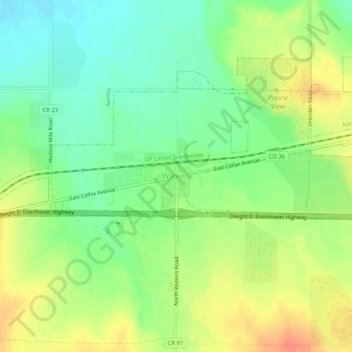
Nom : Carte topographique Watkins, altitude, relief.
Lieu : Watkins, Adams County, Colorado, 80137, United States (39.72434 -104.62320 39.76434 -104.58320)
Altitude moyenne : 1.688 m
Altitude minimum : 1.666 m
Altitude maximum : 1.714 m
Faire un don
Équipez-vous pour votre prochaine aventure :
En tant que Partenaire Amazon, ce site perçoit une commission sur les achats éligibles sans surcoût pour vous.
Autres cartes topographiques
Cliquez sur une carte pour visualiser sa topographie, son altitude et son relief.
Aurora
United States > Colorado > Adams County
Aurora's official elevation, posted on signs at the city limits, is 5,471 feet (1,668 m). However, the city spans a difference in elevation of nearly 1,000 feet (300 m). The lowest elevation of 5,285 feet (1,611 m) is found at the point where Sand Creek crosses the city limit in the northwest corner of the…
Altitude moyenne : 1.691 m
Faire un don
Équipez-vous pour votre prochaine aventure :
En tant que Partenaire Amazon, ce site perçoit une commission sur les achats éligibles sans surcoût pour vous.
Bennett
United States > Colorado > Adams County
Bennett is located at coordinates 39°45′32″N 104°25′39″W / 39.7589°N 104.4275°W / 39.7589; -104.4275 at an elevation of 5486 at the intersection of State Highways 36 and 79, just north of Interstate 70.
Altitude moyenne : 1.692 m
Faire un don
Équipez-vous pour votre prochaine aventure :
En tant que Partenaire Amazon, ce site perçoit une commission sur les achats éligibles sans surcoût pour vous.
Brighton
United States > Colorado > Adams County
Brighton is a suburb of Denver located at coordinates 39°59′07″N 104°49′14″W / 39.9853°N 104.8205°W / 39.9853; -104.8205 (Brighton, Colorado) at an elevation of 4,987 feet (1,520 m).
Altitude moyenne : 1.545 m
Aurora
United States > Colorado > Adams County
Aurora's official elevation, posted on signs at the city limits, is 5,471 feet (1,668 m). However, the city spans a difference in elevation of nearly 1,000 feet (300 m). The lowest elevation of 5,285 feet (1,611 m) is found at the point where Sand Creek crosses the city limit in the northwest corner of the…
Altitude moyenne : 1.691 m
Faire un don
Équipez-vous pour votre prochaine aventure :
En tant que Partenaire Amazon, ce site perçoit une commission sur les achats éligibles sans surcoût pour vous.
Faire un don
Équipez-vous pour votre prochaine aventure :
En tant que Partenaire Amazon, ce site perçoit une commission sur les achats éligibles sans surcoût pour vous.
Brighton
United States > Colorado > Adams County
Brighton is a suburb of Denver located at coordinates 39°59′07″N 104°49′14″W / 39.9853°N 104.8205°W / 39.9853; -104.8205 (Brighton, Colorado) at an elevation of 4,987 feet (1,520 m).
Altitude moyenne : 1.545 m
Bennett
United States > Colorado > Adams County
Bennett is located at coordinates 39°45′32″N 104°25′39″W / 39.7589°N 104.4275°W / 39.7589; -104.4275 at an elevation of 5486 at the intersection of State Highways 36 and 79, just north of Interstate 70.
Altitude moyenne : 1.692 m
Faire un don
Équipez-vous pour votre prochaine aventure :
En tant que Partenaire Amazon, ce site perçoit une commission sur les achats éligibles sans surcoût pour vous.
Broomfield McKay Bike Park
United States > Colorado > Adams County > Broomfield
Altitude moyenne : 1.601 m
Faire un don
Équipez-vous pour votre prochaine aventure :
En tant que Partenaire Amazon, ce site perçoit une commission sur les achats éligibles sans surcoût pour vous.