Carte topographique West Byfleet
Carte interactive
Cliquez sur la carte pour afficher l’altitude.
À propos de cette carte
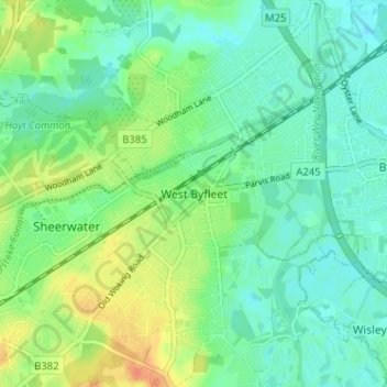
The surface undulates gently from the west to the east, where West Byfleet's land is drained in the parish of Byfleet itself by the River Wey. Soil ranges from sandy acidic soil in the west to more alluvial soil in the east, underlain by a mixture of gravel and clay. Elevations range from 18m Above Ordnance Datum to 33m.
Autres cartes topographiques
Cliquez sur une carte pour visualiser sa topographie, son altitude et son relief.
Brookwood Country Park
United Kingdom > England > Surrey > Woking > Knaphill
Brookwood Country Park, Hermitage Woods, Knaphill, Woking, Surrey, England, United Kingdom
Altitude moyenne : 47 m
Old Woking
United Kingdom > England > Surrey > Woking
Old Woking, Woking, Surrey, England, GU22 9HD, United Kingdom
Altitude moyenne : 31 m
Brookwood
United Kingdom > England > Surrey > Woking
Brookwood, Woking, Surrey, England, GU24 0HG, United Kingdom
Altitude moyenne : 48 m
Sutton Green
United Kingdom > England > Surrey > Woking
Sutton Green, Woking, Surrey, England, GU4 7QD, United Kingdom
Altitude moyenne : 32 m
Mayford
United Kingdom > England > Surrey > Woking
Mayford, Woking, Surrey, England, GU22 0NL, United Kingdom
Altitude moyenne : 35 m
Knaphill
United Kingdom > England > Surrey > Woking
Knaphill, Woking, Surrey, England, GU21 2DG, United Kingdom
Altitude moyenne : 43 m
Horsell Common
United Kingdom > England > Surrey > Woking > Horsell > Durnford Farm
Horsell Common, Durnford Farm, Horsell, Woking, Surrey, South East England, England, United Kingdom
Altitude moyenne : 29 m
Byfleet
United Kingdom > England > Surrey > Woking
Byfleet, Woking, Surrey, England, KT14 7PN, United Kingdom
Altitude moyenne : 27 m
Horsell
United Kingdom > England > Surrey > Woking
Horsell, Woking, Surrey, England, GU21 4QZ, United Kingdom
Altitude moyenne : 32 m