
Faire un don
Équipez-vous pour votre prochaine aventure :
En tant que Partenaire Amazon, ce site perçoit une commission sur les achats éligibles sans surcoût pour vous.
Carte topographique Bacolod
Cliquez sur la carte pour afficher l’altitude.
Faire un don
Équipez-vous pour votre prochaine aventure :
En tant que Partenaire Amazon, ce site perçoit une commission sur les achats éligibles sans surcoût pour vous.
Bacolod
Bacólod (English: Bacolod), is derived from bakólod (Old Spelling: bacólod), the Old Hiligaynon (Old Ilonggo) (Old Spelling: Ylongo and Ilongo) word for a "hill, turtle, mound, rise, hillock, down, any small eminence or elevation", since the resettlement was founded on a stony, hilly area, now the barangay of Granada. It was officially called Ciudad de Bacólod (City of Bacolod) when Municipalidad de Bacólod (Municipality of Bacolod) was converted into a city in 1938.
Faire un don
Équipez-vous pour votre prochaine aventure :
En tant que Partenaire Amazon, ce site perçoit une commission sur les achats éligibles sans surcoût pour vous.
À propos de cette carte
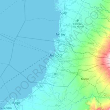
Nom : Carte topographique Bacolod, altitude, relief.
Lieu : Bacolod, Western Visayas, 6100, Philippines (10.51628 122.79138 10.83628 123.11138)
Altitude moyenne : 49 m
Altitude minimum : -1 m
Altitude maximum : 495 m
Faire un don
Équipez-vous pour votre prochaine aventure :
En tant que Partenaire Amazon, ce site perçoit une commission sur les achats éligibles sans surcoût pour vous.
Autres cartes topographiques
Cliquez sur une carte pour visualiser sa topographie, son altitude et son relief.
Limasawa
Limasawa was the second island (after Suluan) of the Philippines that the Magellan Expedition landed on. Antonio Pigafetta documented the island as "Mazaua". He described it as being inhabited with cultivated fields. In March 28, 1521 the Magellan Expedition met with two rulers, Rajah Colambu and Rahah Siaui,…
Altitude moyenne : 1 m
Faire un don
Équipez-vous pour votre prochaine aventure :
En tant que Partenaire Amazon, ce site perçoit une commission sur les achats éligibles sans surcoût pour vous.
Faire un don
Équipez-vous pour votre prochaine aventure :
En tant que Partenaire Amazon, ce site perçoit une commission sur les achats éligibles sans surcoût pour vous.
Faire un don
Équipez-vous pour votre prochaine aventure :
En tant que Partenaire Amazon, ce site perçoit une commission sur les achats éligibles sans surcoût pour vous.
Faire un don
Équipez-vous pour votre prochaine aventure :
En tant que Partenaire Amazon, ce site perçoit une commission sur les achats éligibles sans surcoût pour vous.
Ilocos Region
The southern parts of the region were severely hit by the 1990 Luzon earthquake. Five municipalities in La Union were affected: Agoo, Aringay, Caba, Santo Tomas, and Tubao with a combined population of 132,208. Many buildings, including the Agoo Municipal hall, the Museo de Iloko, the parish church of Aringay,…
Altitude moyenne : 219 m
Faire un don
Équipez-vous pour votre prochaine aventure :
En tant que Partenaire Amazon, ce site perçoit une commission sur les achats éligibles sans surcoût pour vous.
Dinagat Islands
Dinagat Islands is a young island-province at the northern tip of Mindanao. Many describe Dinagat Islands as a hidden gem of the Caraga Region XIII. The Islands are enriched with great bio-diversity, abundant natural wonders and rich resources. Dinagat Islands has a multitude of fascinating white sandy beaches…
Altitude moyenne : 24 m
Faire un don
Équipez-vous pour votre prochaine aventure :
En tant que Partenaire Amazon, ce site perçoit une commission sur les achats éligibles sans surcoût pour vous.
Ibaan
Ibaan is located 96 kilometres (60 mi) south of Manila. It is bounded on the northwest by San Jose, the northeast by Lipa City, the east by Rosario, the southeast by Taysan, and the southwest by Batangas City. It has a land area of 68.99 square kilometres (26.64 sq mi) at an altitude of 124 metres (407 ft)…
Altitude moyenne : 126 m
Digos
The land topography of Digos ranges from hilly to mountainous in the north-northeast portion and flat and slightly rolling at the coastal barangays, while the urban area and the surrounding barangays in the south portion are generally flat. Generally, climate in Digos falls under the fourth type while wind…
Altitude moyenne : 499 m
Candoni
Philippines > Negros Occidental
Candoni is located 130 kilometres (81 mi) south-south-west of the provincial capital, Bacolod. It is approximately four hour drive from Bacolod City aboard a public utility vehicle and about two hours and 45 minutes on a private car. From Bacolod City, buses are available at Bacolod South Terminal. From…
Altitude moyenne : 308 m
Fuga Island
Fuga has an area of 70 square kilometres (27 sq mi) and a population of 2,015 people. The principal settlement is Naguilian (Musa) village on the southern coast. The highest peak is Mount Nanguringan in the northeast, with an elevation of 191 metres (627 ft).
Altitude moyenne : 9 m
Faire un don
Équipez-vous pour votre prochaine aventure :
En tant que Partenaire Amazon, ce site perçoit une commission sur les achats éligibles sans surcoût pour vous.
Camiling
Mostly of plain topography but some parts are hilly to mountainous in which the barangays of Papaac, Bacsay, Birbira and Cayasan, to name a few. The deeper part of the mountains can be described as a place where wild animals live, such as deer, Toddy cat (Musang), wild boar (Baboy ramo), Monitor lizard…
Altitude moyenne : 32 m
Caballo Island
Philippines > Cavite > Cavite City
Caballo Island (which means "Horse Island" in Spanish) is a bluff, rocky island located at the entrance to Manila Bay in the Philippines. It is about 1.2 km (0.75 mi) long with the highest elevation at 381 feet high. Caballo, along with the larger Corregidor (2 km to the north), divides the entrance to the bay…
Altitude moyenne : 0 m
Faire un don
Équipez-vous pour votre prochaine aventure :
En tant que Partenaire Amazon, ce site perçoit une commission sur les achats éligibles sans surcoût pour vous.
Faire un don
Équipez-vous pour votre prochaine aventure :
En tant que Partenaire Amazon, ce site perçoit une commission sur les achats éligibles sans surcoût pour vous.
Faire un don
Équipez-vous pour votre prochaine aventure :
En tant que Partenaire Amazon, ce site perçoit une commission sur les achats éligibles sans surcoût pour vous.
Faire un don
Équipez-vous pour votre prochaine aventure :
En tant que Partenaire Amazon, ce site perçoit une commission sur les achats éligibles sans surcoût pour vous.
Faire un don
Équipez-vous pour votre prochaine aventure :
En tant que Partenaire Amazon, ce site perçoit une commission sur les achats éligibles sans surcoût pour vous.
Faire un don
Équipez-vous pour votre prochaine aventure :
En tant que Partenaire Amazon, ce site perçoit une commission sur les achats éligibles sans surcoût pour vous.
Faire un don
Équipez-vous pour votre prochaine aventure :
En tant que Partenaire Amazon, ce site perçoit une commission sur les achats éligibles sans surcoût pour vous.
Pampanga River
Its main tributaries are Peñaranda and the Coronel-Santor rivers on the eastern side of the basin and the Rio Chico River from the northwest side. The Angat River joins the Pampanga River at Calumpit, Bulacan via the Bagbag River. Mount Arayat (elevation: 1,026 metres (3,366 ft)) stands in the middle of the…
Altitude moyenne : 190 m
Faire un don
Équipez-vous pour votre prochaine aventure :
En tant que Partenaire Amazon, ce site perçoit une commission sur les achats éligibles sans surcoût pour vous.
Faire un don
Équipez-vous pour votre prochaine aventure :
En tant que Partenaire Amazon, ce site perçoit une commission sur les achats éligibles sans surcoût pour vous.
Faire un don
Équipez-vous pour votre prochaine aventure :
En tant que Partenaire Amazon, ce site perçoit une commission sur les achats éligibles sans surcoût pour vous.
Faire un don
Équipez-vous pour votre prochaine aventure :
En tant que Partenaire Amazon, ce site perçoit une commission sur les achats éligibles sans surcoût pour vous.
Faire un don
Équipez-vous pour votre prochaine aventure :
En tant que Partenaire Amazon, ce site perçoit une commission sur les achats éligibles sans surcoût pour vous.
Faire un don
Équipez-vous pour votre prochaine aventure :
En tant que Partenaire Amazon, ce site perçoit une commission sur les achats éligibles sans surcoût pour vous.
Faire un don
Équipez-vous pour votre prochaine aventure :
En tant que Partenaire Amazon, ce site perçoit une commission sur les achats éligibles sans surcoût pour vous.
Mataasnakahoy
Mataasnakahoy has 16 barangays and its total land area is 22.10 square kilometers (8.53 sq mi). It is bounded by Balete and Lipa City with Taal Lake on its western edge. The town is known for its cool climate due to its high elevation of 379 meters (1,243 ft).
Altitude moyenne : 222 m
Faire un don
Équipez-vous pour votre prochaine aventure :
En tant que Partenaire Amazon, ce site perçoit une commission sur les achats éligibles sans surcoût pour vous.
Pantabangan Dam
Philippines > Nueva Ecija > Pantabangan > Fatima
The dam is a 107 m (351 ft) tall and 1,615 m (5,299 ft) long embankment-type with 12,000,000 cu yd (9,174,658 m3) of homogeneous earth-fill and an impervious core. The crest of the dam is 12 m (39 ft) wide while the widest part of its base is 535 m (1,755 ft). The dam's crest sits at an elevation of 232 m (761…
Altitude moyenne : 210 m
Faire un don
Équipez-vous pour votre prochaine aventure :
En tant que Partenaire Amazon, ce site perçoit une commission sur les achats éligibles sans surcoût pour vous.
Faire un don
Équipez-vous pour votre prochaine aventure :
En tant que Partenaire Amazon, ce site perçoit une commission sur les achats éligibles sans surcoût pour vous.
Faire un don
Équipez-vous pour votre prochaine aventure :
En tant que Partenaire Amazon, ce site perçoit une commission sur les achats éligibles sans surcoût pour vous.