
Faire un don
Équipez-vous pour votre prochaine aventure :
En tant que Partenaire Amazon, ce site perçoit une commission sur les achats éligibles sans surcoût pour vous.
Carte topographique Anna
Cliquez sur la carte pour afficher l’altitude.
Faire un don
Équipez-vous pour votre prochaine aventure :
En tant que Partenaire Amazon, ce site perçoit une commission sur les achats éligibles sans surcoût pour vous.
Anna
The coming of the railroad can be credited for prompting the founding of the City of Anna, although, from the time of the George Rogers Clark expedition into Southern Illinois country, emigrants recognized its agricultural possibilities. Centrally located in Anna Precinct of Union County, Anna was established by ordinance following the election of Trustees in 1855, although the plot was recorded in the county records on March 3, 1854. The area's elevation and fertile soil have made fruit farming—particularly the growth of grapes for winemaking—one of the area's principal businesses. For the purpose of farming, fruit growing, gardening, and dairying, the lands in and around Anna are not surpassed in Southern Illinois. The precinct in which Anna lies is situated on the divide between the waters of the Ohio and Mississippi Rivers and is well drained by the Cache, Cypress, and Big Creeks. Many cool springs of water aid materially in cattle farming in this area.
Faire un don
Équipez-vous pour votre prochaine aventure :
En tant que Partenaire Amazon, ce site perçoit une commission sur les achats éligibles sans surcoût pour vous.
À propos de cette carte
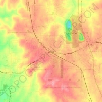
Nom : Carte topographique Anna, altitude, relief.
Lieu : Anna, Union County, Illinois, 62906, United States (37.44547 -89.26132 37.47584 -89.20744)
Altitude moyenne : 183 m
Altitude minimum : 108 m
Altitude maximum : 218 m
Faire un don
Équipez-vous pour votre prochaine aventure :
En tant que Partenaire Amazon, ce site perçoit une commission sur les achats éligibles sans surcoût pour vous.
Autres cartes topographiques
Cliquez sur une carte pour visualiser sa topographie, son altitude et son relief.