
Carte topographique San Fernando
Cliquez sur la carte pour afficher l’altitude.
À propos de cette carte
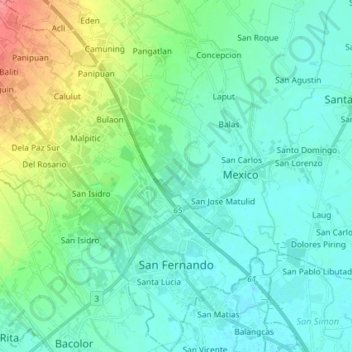
Nom : Carte topographique San Fernando, altitude, relief.
Lieu : San Fernando, Pampanga, Central Luzon, 2000, Philippines (15.00515 120.59430 15.13424 120.72781)
Altitude moyenne : 16 m
Altitude minimum : 0 m
Altitude maximum : 63 m
Autres cartes topographiques
Cliquez sur une carte pour visualiser sa topographie, son altitude et son relief.
Angeles
Sapangbato is the largest barangay in Angeles in terms of territory, with a total land area of 104,694 sq. meters and a population of 11,262. Located northwest of Angeles near Clark Freeport Zone, it is identified as the barangay in Angeles with the highest elevation of 750 feet above sea level. It is home to…
Altitude moyenne : 128 m
Mount Arayat
Philippines > Pampanga > Arayat
Mount Arayat stands in the middle of the flat Central Luzon Plain, consisting of rice paddies and a typical elevation of about 15 to 35 metres MSL. The mountain is topped by a circular volcanic crater about 1.2 kilometres (0.75 mi) in diameter, much of which has collapsed on the western and part of the…
Altitude moyenne : 639 m