
Faire un don
Équipez-vous pour votre prochaine aventure :
En tant que Partenaire Amazon, ce site perçoit une commission sur les achats éligibles sans surcoût pour vous.
Carte topographique Ashburnham
Cliquez sur la carte pour afficher l’altitude.
Faire un don
Équipez-vous pour votre prochaine aventure :
En tant que Partenaire Amazon, ce site perçoit une commission sur les achats éligibles sans surcoût pour vous.
Ashburnham
According to the United States Census Bureau, the town has a total area of 41.0 square miles (106 km2), of which 38.7 square miles (100 km2) is land and 2.3 square miles (6.0 km2) (5.68%) is water. Ashburnham has two distinct topographical areas, hilly to the east and relatively flat high ground to the west. To the east, Mount Watatic and Little Watatic Mountain rise in the northeastern part of town, with Jewell Hill to the southeast and Blood Hill rising just over the town line. In the western part of town are several lakes, including Lake Wampanoag, Sunset Lake, Lake Watatic, Wallace Pond, and the Upper & Lower Naukeag Lakes, all of which (except Lake Wampanoag) feed into the headwaters of the Millers River, which flows westward towards the Connecticut River. Several brooks also feed into these lakes and ponds, along with several others between the hills in the eastern part of town. Several areas scattered around the town are protected as part of Ashburnham State Forest, as well as two smaller areas which are parts of Mount Watatic State Wildlife Management Area and a small portion of the High Ridge Wildlife Management Area to the south.
Faire un don
Équipez-vous pour votre prochaine aventure :
En tant que Partenaire Amazon, ce site perçoit une commission sur les achats éligibles sans surcoût pour vous.
À propos de cette carte
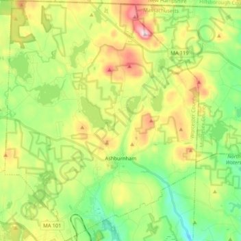
Nom : Carte topographique Ashburnham, altitude, relief.
Altitude moyenne : 342 m
Altitude minimum : 216 m
Altitude maximum : 544 m
Faire un don
Équipez-vous pour votre prochaine aventure :
En tant que Partenaire Amazon, ce site perçoit une commission sur les achats éligibles sans surcoût pour vous.
Autres cartes topographiques
Cliquez sur une carte pour visualiser sa topographie, son altitude et son relief.
Faire un don
Équipez-vous pour votre prochaine aventure :
En tant que Partenaire Amazon, ce site perçoit une commission sur les achats éligibles sans surcoût pour vous.
Wachusett Station
United States > Massachusetts > Worcester County > Fitchburg
Altitude moyenne : 229 m
Central (Stanley) Woolen Mill District Park
United States > Massachusetts > Worcester County > Uxbridge
Altitude moyenne : 80 m
Faire un don
Équipez-vous pour votre prochaine aventure :
En tant que Partenaire Amazon, ce site perçoit une commission sur les achats éligibles sans surcoût pour vous.
Crow Hill Ledges
United States > Massachusetts > Worcester County > Westminster
Altitude moyenne : 293 m
Olde English Village
United States > Massachusetts > Worcester County > Gardner
Altitude moyenne : 308 m
Faire un don
Équipez-vous pour votre prochaine aventure :
En tant que Partenaire Amazon, ce site perçoit une commission sur les achats éligibles sans surcoût pour vous.
Vernon Hill
United States > Massachusetts > Worcester County > Worcester > Quinsigamond Village
Altitude moyenne : 162 m
Faire un don
Équipez-vous pour votre prochaine aventure :
En tant que Partenaire Amazon, ce site perçoit une commission sur les achats éligibles sans surcoût pour vous.
Tatnuck
United States > Massachusetts > Worcester County > Worcester > Tatnuck Square
Altitude moyenne : 221 m
Faire un don
Équipez-vous pour votre prochaine aventure :
En tant que Partenaire Amazon, ce site perçoit une commission sur les achats éligibles sans surcoût pour vous.
Institute Park
United States > Massachusetts > Worcester County > Worcester > Belmont Hill
Altitude moyenne : 170 m
Faire un don
Équipez-vous pour votre prochaine aventure :
En tant que Partenaire Amazon, ce site perçoit une commission sur les achats éligibles sans surcoût pour vous.
Hadwen Park
United States > Massachusetts > Worcester County > Worcester > Heard Street
Altitude moyenne : 166 m
Faire un don
Équipez-vous pour votre prochaine aventure :
En tant que Partenaire Amazon, ce site perçoit une commission sur les achats éligibles sans surcoût pour vous.
Thompsons Pond Dam
United States > Massachusetts > Worcester County > Spencer
Altitude moyenne : 278 m
Faire un don
Équipez-vous pour votre prochaine aventure :
En tant que Partenaire Amazon, ce site perçoit une commission sur les achats éligibles sans surcoût pour vous.
Faire un don
Équipez-vous pour votre prochaine aventure :
En tant que Partenaire Amazon, ce site perçoit une commission sur les achats éligibles sans surcoût pour vous.
Northbridge Center
United States > Massachusetts > Worcester County > Northbridge
Altitude moyenne : 124 m
Faire un don
Équipez-vous pour votre prochaine aventure :
En tant que Partenaire Amazon, ce site perçoit une commission sur les achats éligibles sans surcoût pour vous.
Blackburn Village
United States > Massachusetts > Worcester County > Ashburnham
Altitude moyenne : 326 m
Phillipston Four Corners
United States > Massachusetts > Worcester County > Phillipston
Altitude moyenne : 335 m
Faire un don
Équipez-vous pour votre prochaine aventure :
En tant que Partenaire Amazon, ce site perçoit une commission sur les achats éligibles sans surcoût pour vous.
Faire un don
Équipez-vous pour votre prochaine aventure :
En tant que Partenaire Amazon, ce site perçoit une commission sur les achats éligibles sans surcoût pour vous.
Faire un don
Équipez-vous pour votre prochaine aventure :
En tant que Partenaire Amazon, ce site perçoit une commission sur les achats éligibles sans surcoût pour vous.
Faire un don
Équipez-vous pour votre prochaine aventure :
En tant que Partenaire Amazon, ce site perçoit une commission sur les achats éligibles sans surcoût pour vous.
South Charlton Reservoir
United States > Massachusetts > Worcester County > Charlton > South Charlton
Altitude moyenne : 203 m
Faire un don
Équipez-vous pour votre prochaine aventure :
En tant que Partenaire Amazon, ce site perçoit une commission sur les achats éligibles sans surcoût pour vous.
Faire un don
Équipez-vous pour votre prochaine aventure :
En tant que Partenaire Amazon, ce site perçoit une commission sur les achats éligibles sans surcoût pour vous.
Jefferson
United States > Massachusetts > Worcester County > Holden > Jefferson
Altitude moyenne : 248 m
West Upton
United States > Massachusetts > Worcester County > Upton > West Upton
Altitude moyenne : 111 m
Hadwen Arboretum
United States > Massachusetts > Worcester County > Worcester > Main South
Altitude moyenne : 165 m
Faire un don
Équipez-vous pour votre prochaine aventure :
En tant que Partenaire Amazon, ce site perçoit une commission sur les achats éligibles sans surcoût pour vous.
Martha Templeton Rock
United States > Massachusetts > Worcester County > Southborough
Altitude moyenne : 95 m
Faire un don
Équipez-vous pour votre prochaine aventure :
En tant que Partenaire Amazon, ce site perçoit une commission sur les achats éligibles sans surcoût pour vous.
Turkey Hill Shores
United States > Massachusetts > Worcester County > Rutland
Altitude moyenne : 312 m
Faire un don
Équipez-vous pour votre prochaine aventure :
En tant que Partenaire Amazon, ce site perçoit une commission sur les achats éligibles sans surcoût pour vous.