
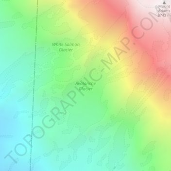
Carte topographique Avalanche Glacier
Carte interactive
Cliquez sur la carte pour afficher l’altitude.
À propos de cette carte
Nom : Carte topographique Avalanche Glacier, altitude, relief.
Altitude moyenne : 2.731 m
Altitude minimum : 2.129 m
Altitude maximum : 3.741 m
Autres cartes topographiques
Cliquez sur une carte pour visualiser sa topographie, son altitude et son relief.
Tukwila
USA > Washington > Tukwila
Tukwila, King County, Washington, 98188, USA
Altitude moyenne : 59 m
Hoquiam
USA > Washington > Hoquiam
Hoquiam, Grays Harbor County, Washington, 98550, USA
Altitude moyenne : 29 m
Maple Valley
USA > Washington > Maple Valley
Maple Valley, King County, Washington, 98038, USA
Altitude moyenne : 160 m
Mount Vernon
USA > Washington > Mount Vernon
Mount Vernon, Skagit County, Washington, USA
Altitude moyenne : 37 m
Challenger Glacier
Challenger Glacier, Little Beaver Trail, Whatcom County, Washington, USA
Altitude moyenne : 1.924 m
Redoubt Glacier
Redoubt Glacier, Depot Creek trail, Whatcom County, Washington, USA
Altitude moyenne : 2.028 m
Lyman Glacier
Lyman Glacier, Highline Trail, Yakima County, Washington, USA
Altitude moyenne : 2.722 m
Sahale Glacier
Sahale Glacier, Sahale Arm Trail, Skagit County, Washington, USA
Altitude moyenne : 2.062 m
Stuart Glacier
Stuart Glacier, Horseshoe Lake Trail, Chelan County, Washington, USA
Altitude moyenne : 2.098 m
Carrie Glacier
Carrie Glacier, Bailey Range Way Trail, Jefferson County, Washington, USA
Altitude moyenne : 1.725 m
Isella Glacier
USA > Washington > Holden Village
Isella Glacier, Cloudy Pass Trail #1256, Holden Village, Chelan County, Washington, USA
Altitude moyenne : 2.258 m
Nisqually Glacier
USA > Washington > Paradise
Nisqually Glacier, Camp Muir Route, Paradise, Pierce County, Washington, USA
Altitude moyenne : 2.711 m
White Chuck Glacier
White Chuck Glacier, Foam Creek Trail, Chelan County, Washington, USA
Altitude moyenne : 2.140 m
Humes Glacier
Humes Glacier, Humes Glacier Route, Jefferson County, Washington, USA
Altitude moyenne : 1.613 m
Terror Glacier
Terror Glacier, Whatcom County, Washington, USA
Altitude moyenne : 1.866 m
Crystal Glacier
Crystal Glacier, Sulfide Glacier Route, Whatcom County, Washington, USA
Altitude moyenne : 2.145 m
Winthrop Glacier
Winthrop Glacier, Glacier Basin Trail, Pierce County, Washington, USA
Altitude moyenne : 2.380 m
Inter Glacier
Inter Glacier, Glacier Basin Trail, Pierce County, Washington, USA
Altitude moyenne : 2.484 m
Company Glacier
USA > Washington > Holden Village
Company Glacier, Cloudy Pass Trail #1256, Holden Village, Chelan County, Washington, USA
Altitude moyenne : 2.164 m
Squak Glacier
Squak Glacier, Squak Glacier Route, Whatcom County, Washington, USA
Altitude moyenne : 2.257 m
Snoqualmie Mountain
Snoqualmie Mountain, King County, Washington, 98068, USA
Altitude moyenne : 1.409 m
Lyall Glacier
Lyall Glacier, Maple Pass Trail, Chelan County, Washington, USA
Altitude moyenne : 1.932 m
Klawatti Glacier
Klawatti Glacier, Lucky ridge boot trail, Skagit County, Washington, USA
Altitude moyenne : 2.001 m
Upper Curtis Glacier
Upper Curtis Glacier, Sulfide Glacier Route, Whatcom County, Washington, USA
Altitude moyenne : 2.059 m
Ptarmigan Glacier
Ptarmigan Glacier, Pacific Crest Trail, Snohomish County, Washington, USA
Altitude moyenne : 2.025 m
East Nooksack Glacier
East Nooksack Glacier, Nooksack Cirque Trail, Whatcom County, Washington, USA
Altitude moyenne : 1.701 m
Ingraham Glacier
USA > Washington > Paradise
Ingraham Glacier, Camp Muir Route, Paradise, Pierce County, Washington, USA
Altitude moyenne : 2.489 m
Entiat Glacier
Entiat Glacier, Mount Maude Summit Approach, Chelan County, Washington, USA
Altitude moyenne : 2.145 m
Mesahchie Glacier
Mesahchie Glacier, Fisher Creek Trail, Skagit County, Washington, USA
Altitude moyenne : 1.950 m
Ice River Glacier
Ice River Glacier, Blue Glacier Primitive Trail, Jefferson County, Washington, USA
Altitude moyenne : 1.640 m
Lynch Glacier
Lynch Glacier, Jade Lake Trail, King County, Washington, USA
Altitude moyenne : 1.962 m
Forbidden Glacier
Forbidden Glacier, Sahale Arm Trail, Skagit County, Washington, USA
Altitude moyenne : 2.048 m
Middle Cascade Glacier
Middle Cascade Glacier, Ptarmigan Traverse, Chelan County, Washington, USA
Altitude moyenne : 1.981 m
Fryingpan Glacier
Fryingpan Glacier, Wonderland Trail, Pierce County, Washington, USA
Altitude moyenne : 2.386 m
Deming Glacier
Deming Glacier, Easton Glacier Route, Whatcom County, Washington, USA
Altitude moyenne : 2.225 m
North Klawatti Glacier
North Klawatti Glacier, Lucky ridge boot trail, Skagit County, Washington, USA
Altitude moyenne : 1.971 m
Olympic Mountains
Olympic Mountains, Jefferson County, Washington, 98305, USA
Altitude moyenne : 511 m
Sarvant Glacier
Sarvant Glacier, Wonderland Trail, Pierce County, Washington, USA
Altitude moyenne : 1.874 m
Conrad Glacier
Conrad Glacier, Pacific Crest Trail, Yakima County, Washington, USA
Altitude moyenne : 2.064 m
Mazama Glacier
Mazama Glacier, South Climb Trail #183, Yakima County, Washington, USA
Altitude moyenne : 2.568 m
Success Glacier
USA > Washington > Paradise
Success Glacier, Van Trump Trail, Paradise, Pierce County, Washington, USA
Altitude moyenne : 2.784 m
Snow Creek Glacier
Snow Creek Glacier, Little Annapurna summit trail, Chelan County, Washington, USA
Altitude moyenne : 2.225 m
Mount Seattle
Mount Seattle, Jefferson County, Washington, USA
Altitude moyenne : 1.441 m