
Faire un don
Équipez-vous pour votre prochaine aventure :
En tant que Partenaire Amazon, ce site perçoit une commission sur les achats éligibles sans surcoût pour vous.
Carte topographique Pilot Butte
Cliquez sur la carte pour afficher l’altitude.
Faire un don
Équipez-vous pour votre prochaine aventure :
En tant que Partenaire Amazon, ce site perçoit une commission sur les achats éligibles sans surcoût pour vous.
Pilot Butte
The 114.22-acre (46.22-hectare) Pilot Butte State Scenic Viewpoint, presented as a gift to the State of Oregon in 1928, is a Bend icon. Pilot Butte itself is a popular hiking destination with two trails to the summit, each gaining about 490 ft (150 m) in elevation. There is also a 1.8-mile (2.9 km) trail around the base of the butte. A scenic road also winds up and around the cone. In 2018, the park was the most visited Oregon state park east of the Cascade Mountains. From the top, the entire city of Bend is visible, as well as several major Cascade peaks including Mount Bachelor, Broken Top, and the Three Sisters, located about 20 mi (32 km) to the west. Bend launches fireworks from Pilot Butte every Independence Day.
Faire un don
Équipez-vous pour votre prochaine aventure :
En tant que Partenaire Amazon, ce site perçoit une commission sur les achats éligibles sans surcoût pour vous.
À propos de cette carte
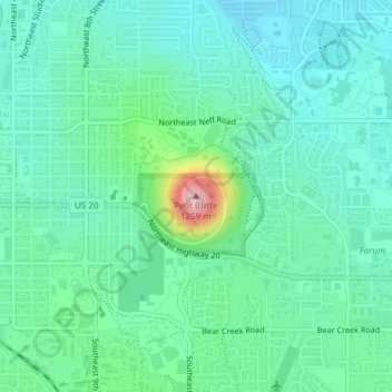
Nom : Carte topographique Pilot Butte, altitude, relief.
Altitude moyenne : 1.112 m
Altitude minimum : 1.071 m
Altitude maximum : 1.260 m
Faire un don
Équipez-vous pour votre prochaine aventure :
En tant que Partenaire Amazon, ce site perçoit une commission sur les achats éligibles sans surcoût pour vous.