Géolocaliser

Carte topographique Grand Valley

Cliquez sur la carte pour afficher l’altitude.

À propos de cette carte

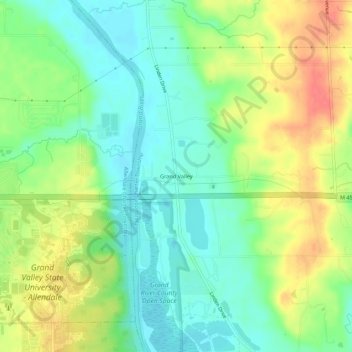
Nom : Carte topographique Grand Valley, altitude, relief.

Lieu : Grand Valley, Tallmadge Charter Township, Ottawa County, Michigan, 49430, United States (42.95447 -85.88976 42.99447 -85.84976)

Altitude moyenne : 199 m

Altitude minimum : 175 m

Altitude maximum : 234 m

Autres cartes topographiques

Cliquez sur une carte pour visualiser sa topographie, son altitude et son relief.

Grand Haven

United States > Michigan > Ottawa County

Altitude moyenne : 182 m

Holland

United States > Michigan > Ottawa County

Altitude moyenne : 199 m

Spring Lake

United States > Michigan > Ottawa County

Altitude moyenne : 179 m

Allendale

United States > Michigan > Ottawa County

Altitude moyenne : 195 m

Merci de soutenir ce site ❤️
Faire un don

Équipez-vous pour votre prochaine aventure :

En tant que Partenaire Amazon, ce site perçoit une commission sur les achats éligibles sans surcoût pour vous.

Park Township

United States > Michigan > Ottawa County

Altitude moyenne : 184 m

Coopersville

United States > Michigan > Ottawa County

Altitude moyenne : 200 m

Robinson Township

United States > Michigan > Ottawa County

Altitude moyenne : 188 m

Jenison

United States > Michigan > Ottawa County

Altitude moyenne : 192 m

Holland

United States > Michigan > Ottawa County

Altitude moyenne : 199 m

Wright

United States > Michigan > Ottawa County > Wright Township

Altitude moyenne : 265 m

Aman Park

United States > Michigan > Ottawa County > Tallmadge

Altitude moyenne : 207 m

Grand Haven

United States > Michigan > Ottawa County

Altitude moyenne : 182 m

Hudsonville

United States > Michigan > Ottawa County

Altitude moyenne : 200 m

Polkton Township

United States > Michigan > Ottawa County

Altitude moyenne : 195 m

Coopersville

United States > Michigan > Ottawa County

Altitude moyenne : 200 m

Chester Township

United States > Michigan > Ottawa County

Altitude moyenne : 233 m

Zeeland

United States > Michigan > Ottawa County

According to the United States Census Bureau, the city has a total area of 3.01 square miles (7.80 km2), of which 2.99 square miles (7.74 km2) is land and 0.02 square miles (0.05 km2) is water. The town itself is located on a hill, giving the city a higher elevation compared to the surrounding township land.…

Altitude moyenne : 192 m

Équipez-vous pour votre prochaine aventure :

🧣Tours de cou - Protection polyvalente contre le froid et le vent
🧯Kits de survie - Équipement essentiel outdoor
📚Guides trekking Europe - Itinéraires longue distance
🧼Entretien Chaussures - Prolongez la vie de vos bottes de randonnée
🩳Pantalons de randonnée - Pantalons confortables et résistants

En tant que Partenaire Amazon, ce site perçoit une commission sur les achats éligibles sans surcoût pour vous.