
Faire un don
Équipez-vous pour votre prochaine aventure :
En tant que Partenaire Amazon, ce site perçoit une commission sur les achats éligibles sans surcoût pour vous.
Carte topographique Otavi
Cliquez sur la carte pour afficher l’altitude.
Faire un don
Équipez-vous pour votre prochaine aventure :
En tant que Partenaire Amazon, ce site perçoit une commission sur les achats éligibles sans surcoût pour vous.
À propos de cette carte
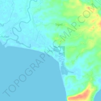
Nom : Carte topographique Otavi, altitude, relief.
Lieu : Otavi, Sorsogon, Bicol Region, Philippines (12.62271 123.88933 12.66271 123.92933)
Altitude moyenne : 9 m
Altitude minimum : 0 m
Altitude maximum : 47 m
Faire un don
Équipez-vous pour votre prochaine aventure :
En tant que Partenaire Amazon, ce site perçoit une commission sur les achats éligibles sans surcoût pour vous.
Autres cartes topographiques
Cliquez sur une carte pour visualiser sa topographie, son altitude et son relief.
Bulusan Lake
Philippines > Sorsogon > San Roque
Lake Bulusan is a lake on Luzon Island in the Philippines. It lies at the heart of Bulusan Volcano National Park which covers a land area of 3,672 hectares (9,070 acres). It has an elevation of 360 metres (1,180 ft) and is located on the southeast flank of Mount Bulusan, an active volcano.
Altitude moyenne : 382 m