
Carte topographique Brandholz
Carte interactive
Cliquez sur la carte pour afficher l’altitude.
À propos de cette carte
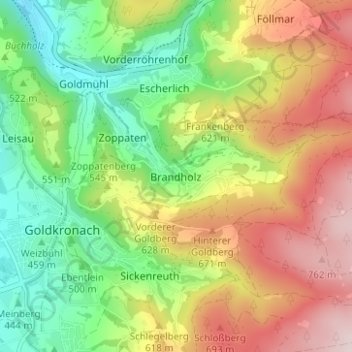
Nom : Carte topographique Brandholz, altitude, relief.
Altitude moyenne : 565 m
Altitude minimum : 389 m
Altitude maximum : 789 m
Autres cartes topographiques
Cliquez sur une carte pour visualiser sa topographie, son altitude et son relief.
Sand
Deutschland > Bayern > Landkreis Bayreuth > Goldkronach > Dressendorf
Sand, Dressendorf, Goldkronach, Landkreis Bayreuth, Bayern, 95497, Deutschland
Altitude moyenne : 434 m
Fürstenstein
Deutschland > Bayern > Landkreis Bayreuth > Goldkronach > Brandholz > Beerfleck
Fürstenstein, Goldbergstraße, Beerfleck, Brandholz, Goldkronach, Landkreis Bayreuth, Bayern, 95497, Deutschland
Altitude moyenne : 621 m