
Faire un don
Équipez-vous pour votre prochaine aventure :
En tant que Partenaire Amazon, ce site perçoit une commission sur les achats éligibles sans surcoût pour vous.
Carte topographique Wymondham
Cliquez sur la carte pour afficher l’altitude.
Faire un don
Équipez-vous pour votre prochaine aventure :
En tant que Partenaire Amazon, ce site perçoit une commission sur les achats éligibles sans surcoût pour vous.
Wymondham
Wymondham's topography is marked by its river meadow and flat, low-lying agricultural landscape, much like the rest of East Anglia. The parish has an area of 17.11 square miles (44.31 km2). The geology is based on chalk, with a layer of boulder clay laid down in the last ice age. The River Tiffey, flowing north, forms a boundary between the built-up town centre and the rural southern part of the parish.
Faire un don
Équipez-vous pour votre prochaine aventure :
En tant que Partenaire Amazon, ce site perçoit une commission sur les achats éligibles sans surcoût pour vous.
À propos de cette carte
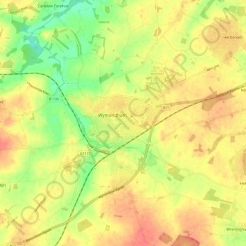
Nom : Carte topographique Wymondham, altitude, relief.
Lieu : Wymondham, South Norfolk, Norfolk, England, NR18, United Kingdom (52.53735 1.07661 52.61070 1.16459)
Altitude moyenne : 43 m
Altitude minimum : 14 m
Altitude maximum : 65 m
Faire un don
Équipez-vous pour votre prochaine aventure :
En tant que Partenaire Amazon, ce site perçoit une commission sur les achats éligibles sans surcoût pour vous.