Géolocaliser

Carte topographique Tyrolean

Cliquez sur la carte pour afficher l’altitude.

À propos de cette carte

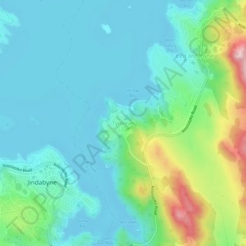
Nom : Carte topographique Tyrolean, altitude, relief.

Lieu : Tyrolean, East Jindabyne, Snowy Monaro Regional Council, New South Wales, 2627, Australia (-36.42751 148.61636 -36.38751 148.65636)

Altitude moyenne : 952 m

Altitude minimum : 897 m

Altitude maximum : 1.134 m

Autres cartes topographiques

Cliquez sur une carte pour visualiser sa topographie, son altitude et son relief.

Sydney

Australia > New South Wales

Sydney's topography is characterized by a diverse landscape that seamlessly blends coastal features with inland plateaus. The city is divided into two primary regions: the relatively flat Cumberland Plain to the south and west of Sydney Harbour, and the elevated Hornsby Plateau to the north. The Cumberland…

Altitude moyenne : 53 m

Barrington Tops

Australia > New South Wales

Altitude moyenne : 1.107 m

Singleton Council

Australia > New South Wales

Altitude moyenne : 238 m

Goulburn

Australia > New South Wales

Owing to its elevation, Goulburn has an oceanic climate (Cfb) with warm summers and cool winters; with a high diurnal range. Its climate is variable much of the year, though generally dry with maximum temperatures ranging from 11.8 °C (53.2 °F) in July to 28.3 °C (82.9 °F) in January. Rainfall is…

Altitude moyenne : 666 m

Campbelltown

Australia > New South Wales

Altitude moyenne : 96 m

Newcastle

Australia > New South Wales

Altitude moyenne : 5 m

Orange

Australia > New South Wales

Orange is a city in the Central Tablelands region of New South Wales, Australia. It is 254 km (158 mi) west of the state capital, Sydney [206 km (128 mi) on a great circle], at an altitude of 862 metres (2,828 ft). Orange had an estimated urban population of 40,493 as of June 2018 making the city a significant…

Altitude moyenne : 852 m

Nerrigundah

Australia > New South Wales

Altitude moyenne : 189 m

Camden Council

Australia > New South Wales

Altitude moyenne : 90 m

Crescent Head

Australia > New South Wales

Altitude moyenne : 7 m

Colo Heights

Australia > New South Wales

Altitude moyenne : 278 m

Katoomba

Australia > New South Wales

Altitude moyenne : 904 m

Mudgee

Australia > New South Wales

Altitude moyenne : 535 m

Port Kembla

Australia > New South Wales

Altitude moyenne : 10 m

Taree

Australia > New South Wales

Altitude moyenne : 17 m

Blue Mountains

Australia > New South Wales

A sandstone plateau dominated by a landscape of endless eucalyptus forests, the Blue Mountains are located at the top of a 470-million-year-old quartzite. In the Permian period, a shallow sea covered the region, when rivers brought shales, siltstones and mudstones. Then during the Mesozoic period, rivers…

Altitude moyenne : 566 m

St Ives

Australia > New South Wales

Altitude moyenne : 125 m

Blackheath

Australia > New South Wales

Blackheath (postcode: 2785) is an Australian town located near the highest point of the Blue Mountains, between Katoomba and Mount Victoria in New South Wales. The town's altitude is about 1,065 metres (3,494 ft) AHD  and it is located about 120 kilometres (75 mi) west north-west of Sydney, 11 kilometres…

Altitude moyenne : 893 m

Wauchope

Australia > New South Wales

Altitude moyenne : 32 m

Thredbo

Australia > New South Wales

Altitude moyenne : 1.780 m

Penrith

Australia > New South Wales > Sydney > Penrith

Penrith is a city in New South Wales, Australia, located in Greater Western Sydney, 55 kilometres (31 mi) west of the Sydney central business district on the banks of the Nepean River, on the outskirts of the Cumberland Plain. Its elevation is 32 metres (105 ft).

Altitude moyenne : 34 m

Perisher Valley

Australia > New South Wales

Altitude moyenne : 1.704 m

Lismore

Australia > New South Wales

Altitude moyenne : 23 m

Mount Victoria

Australia > New South Wales

Mount Victoria (postcode: 2786) is a small township in the Blue Mountains of New South Wales, Australia. Mount Victoria is geographically the western most village and suburb of Greater Sydney on the great western highway in the City of Blue Mountains, located about 120 kilometres (75 mi) west-northwest by road…

Altitude moyenne : 901 m

Glenbrook

Australia > New South Wales

Altitude moyenne : 168 m

Urunga

Australia > New South Wales

Altitude moyenne : 13 m

Yass

Australia > New South Wales

Yass is located 280 km south-west of Sydney, on the Hume Highway. The Yass River, which is a tributary of the Murrumbidgee River, flows through the town. Yass is 59 km from Canberra; lying at an elevation of 505 m AMSL.

Altitude moyenne : 533 m

Kariong

Australia > New South Wales > Gosford

Altitude moyenne : 86 m

Edmondson Park

Australia > New South Wales > Sydney

Altitude moyenne : 56 m

Ocean Shores

Australia > New South Wales

Altitude moyenne : 12 m

Mid-Coast Council

Australia > New South Wales

Altitude moyenne : 278 m

Central Coast Council

Australia > New South Wales

Altitude moyenne : 103 m

St Georges Basin

Australia > New South Wales

Altitude moyenne : 18 m

Capertee

Australia > New South Wales

Altitude moyenne : 757 m

Armidale

Australia > New South Wales

Altitude moyenne : 1.036 m

Balmain

Australia > New South Wales > Sydney

Altitude moyenne : 12 m

Woy Woy

Australia > New South Wales

Altitude moyenne : 35 m

Albion Park

Australia > New South Wales

Altitude moyenne : 62 m

Normanhurst

Australia > New South Wales

Altitude moyenne : 165 m

Coogee

Australia > New South Wales

Altitude moyenne : 35 m

Quakers Hill

Australia > New South Wales

Altitude moyenne : 35 m

Sydney

Australia > New South Wales > Sydney

Altitude moyenne : 23 m

Wamberal

Australia > New South Wales

Altitude moyenne : 34 m

North Nowra

Australia > New South Wales

Altitude moyenne : 33 m

Kiama

Australia > New South Wales

Altitude moyenne : 29 m

Braidwood

Australia > New South Wales

Altitude moyenne : 674 m

Budgewoi

Australia > New South Wales

Altitude moyenne : 2 m

Fingal Head

Australia > New South Wales

Altitude moyenne : 4 m

Rocky River

Australia > New South Wales

Altitude moyenne : 1.008 m

Jindera

Australia > New South Wales

Altitude moyenne : 272 m

Charbon

Australia > New South Wales

Altitude moyenne : 732 m

Mororo

Australia > New South Wales

Altitude moyenne : 35 m

Roseberg

Australia > New South Wales

Altitude moyenne : 611 m

Eungella

Australia > New South Wales

Altitude moyenne : 144 m

Tirrannaville

Australia > New South Wales

Altitude moyenne : 698 m

Port Macquarie

Australia > New South Wales

Altitude moyenne : 5 m

Kurrajong Heights

Australia > New South Wales > Sydney

Altitude moyenne : 385 m

Balgowlah

Australia > New South Wales > Sydney

Altitude moyenne : 40 m

Newnes Plateau

Australia > New South Wales

Altitude moyenne : 889 m

Nambucca Heads

Australia > New South Wales

Altitude moyenne : 16 m

Northern Beaches

Australia > New South Wales > Sydney

Altitude moyenne : 67 m

Tuncurry

Australia > New South Wales

Altitude moyenne : 2 m

Hay

Australia > New South Wales > Hay Shire Council

Altitude moyenne : 90 m

Hurstville

Australia > New South Wales > Sydney

Altitude moyenne : 50 m

Tabulam

Australia > New South Wales

Altitude moyenne : 268 m

Macquarie Park

Australia > New South Wales > Sydney

Altitude moyenne : 59 m

Parramatta

Australia > New South Wales

Altitude moyenne : 22 m

Mosman

Australia > New South Wales > Sydney

Altitude moyenne : 29 m

Tahmoor

Australia > New South Wales

Altitude moyenne : 269 m

Botany Bay

Australia > New South Wales > Sydney

Altitude moyenne : 8 m

Concord

Australia > New South Wales > Sydney

Altitude moyenne : 12 m

Bega

Australia > New South Wales

Altitude moyenne : 44 m

Rooty Hill

Australia > New South Wales > Sydney

Altitude moyenne : 52 m

Balgowlah Heights

Australia > New South Wales > Sydney

Altitude moyenne : 25 m

West Pennant Hills

Australia > New South Wales

Altitude moyenne : 130 m

Freemans Reach

Australia > New South Wales > Sydney

Altitude moyenne : 22 m

Menangle Park

Australia > New South Wales > Sydney

Altitude moyenne : 92 m

Three Mile Dam

Australia > New South Wales

Altitude moyenne : 1.450 m

Lake Macquarie

Australia > New South Wales > Silverwater

Altitude moyenne : 20 m

Blue Mountains

Australia > New South Wales

A sandstone plateau dominated by a landscape of endless eucalyptus forests, the Blue Mountains are located at the top of a 470-million-year-old quartzite. In the Permian period, a shallow sea covered the region, when rivers brought shales, siltstones and mudstones. Then during the Mesozoic period, rivers…

Altitude moyenne : 566 m

Kanimbla

Australia > New South Wales

Altitude moyenne : 739 m

Torrington

Australia > New South Wales

Altitude moyenne : 936 m

Eastern Suburbs

Australia > New South Wales > Sydney

Altitude moyenne : 13 m

Lake Jindabyne

Australia > New South Wales > Jindabyne

Altitude moyenne : 1.091 m

Deepwater

Australia > New South Wales

Altitude moyenne : 1.007 m

Olney

Australia > New South Wales

Altitude moyenne : 226 m

Oberon Council

Australia > New South Wales

Altitude moyenne : 899 m

Byron Bay

Australia > New South Wales

Byron Bay, located in northeastern New South Wales, Australia, is characterized by diverse topography shaped by its geological history. The town is part of the erosion caldera of the ancient Tweed Volcano, which erupted approximately 23 million years ago, resulting in the rich volcanic soils that define the…

Altitude moyenne : 7 m

Baulkham Hills

Australia > New South Wales

Altitude moyenne : 93 m

Équipez-vous pour votre prochaine aventure :

🧥Vestes coupe-vent - Protection contre le vent
🧭Boussoles de Visée - Boussoles haute précision pour lecture de cartes topographiques
🧥Coupe-vents Imperméables - Protection Gore-Tex et respirante pour vos sorties
🎒Sacs à dos de randonnée - Sacs ergonomiques pour sorties à la journée ou en itinérance
🩹Soins des Pieds - Récupération rapide après l'effort

En tant que Partenaire Amazon, ce site perçoit une commission sur les achats éligibles sans surcoût pour vous.