
Faire un don
Équipez-vous pour votre prochaine aventure :
En tant que Partenaire Amazon, ce site perçoit une commission sur les achats éligibles sans surcoût pour vous.
Carte topographique Alta Sierra
Cliquez sur la carte pour afficher l’altitude.
Faire un don
Équipez-vous pour votre prochaine aventure :
En tant que Partenaire Amazon, ce site perçoit une commission sur les achats éligibles sans surcoût pour vous.
Alta Sierra
Alta Sierra was laid out by property developers in the 1960s. Alta Sierra is a golf course community, with homes built around the Alta Sierra Country Club, a semi-private 18 hole course built in 1964. The community has a member-owned airport with a 2800-foot runway. The community is located just east of California State Highway 49, at an elevation of approximately 2300 feet, between the cities of Grass Valley, California to the north and Auburn, California to the south. There is a small commercial district with several restaurants, a gas station, a market and personal service businesses. There is also an elementary school and a motel.
Faire un don
Équipez-vous pour votre prochaine aventure :
En tant que Partenaire Amazon, ce site perçoit une commission sur les achats éligibles sans surcoût pour vous.
À propos de cette carte
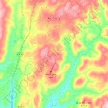
Nom : Carte topographique Alta Sierra, altitude, relief.
Lieu : Alta Sierra, Nevada County, California, United States (39.08918 -121.08055 39.15229 -121.01878)
Altitude moyenne : 603 m
Altitude minimum : 449 m
Altitude maximum : 780 m
Faire un don
Équipez-vous pour votre prochaine aventure :
En tant que Partenaire Amazon, ce site perçoit une commission sur les achats éligibles sans surcoût pour vous.