
Faire un don
Équipez-vous pour votre prochaine aventure :
En tant que Partenaire Amazon, ce site perçoit une commission sur les achats éligibles sans surcoût pour vous.
Carte topographique Mount Elbert
Cliquez sur la carte pour afficher l’altitude.
Faire un don
Équipez-vous pour votre prochaine aventure :
En tant que Partenaire Amazon, ce site perçoit une commission sur les achats éligibles sans surcoût pour vous.
Mount Elbert
Mount Elbert is the highest summit of the Rocky Mountains of North America. With an elevation of 14,438 feet (4400.58 m), it is also the highest point in the U.S. state of Colorado and the second-highest summit in the contiguous United States after Mount Whitney, which is slightly taller. The ultra-prominent fourteener is the highest peak in the Sawatch Range, as well as the highest point in the entire Mississippi River drainage basin. Mount Elbert is located in San Isabel National Forest, 12.1 miles (19.4 km) southwest (bearing 223°) of the city of Leadville in Lake County, Colorado.
Faire un don
Équipez-vous pour votre prochaine aventure :
En tant que Partenaire Amazon, ce site perçoit une commission sur les achats éligibles sans surcoût pour vous.
À propos de cette carte
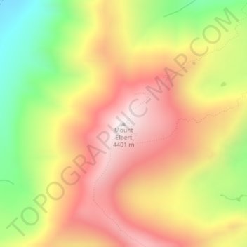
Nom : Carte topographique Mount Elbert, altitude, relief.
Lieu : Mount Elbert, Lake County, Colorado, United States (39.11770 -106.44543 39.11780 -106.44533)
Altitude moyenne : 3.959 m
Altitude minimum : 3.422 m
Altitude maximum : 4.394 m
Faire un don
Équipez-vous pour votre prochaine aventure :
En tant que Partenaire Amazon, ce site perçoit une commission sur les achats éligibles sans surcoût pour vous.
Autres cartes topographiques
Cliquez sur une carte pour visualiser sa topographie, son altitude et son relief.
Leadville
United States > Colorado > Lake County
The City of Leadville is a statutory city that is the county seat, the most populous community, and the only incorporated municipality in Lake County, Colorado, United States. The city population was 2,602 at the 2010 census and an estimated 2,762 in 2018. It is situated at an elevation of 10,152 feet (3,094…
Altitude moyenne : 3.107 m
Mount Massive Wilderness
United States > Colorado > Lake County
The Mount Massive Wilderness is a federally designated wilderness area in the Sawatch Range, located in the U.S. state of Colorado. It is operated jointly by the United States Forest Service and the Fish and Wildlife Service as part of the San Isabel National Forest and the Leadville National Fish Hatchery. It…
Altitude moyenne : 3.432 m
Leadville
United States > Colorado > Lake County
The City of Leadville is a statutory city that is the county seat, the most populous community, and the only incorporated municipality in Lake County, Colorado, United States. The city population was 2,602 at the 2010 census and an estimated 2,762 in 2018. It is situated at an elevation of 10,152 feet (3,094…
Altitude moyenne : 3.107 m