
Faire un don
Équipez-vous pour votre prochaine aventure :
En tant que Partenaire Amazon, ce site perçoit une commission sur les achats éligibles sans surcoût pour vous.
Carte topographique Red Earth Creek
Cliquez sur la carte pour afficher l’altitude.
Faire un don
Équipez-vous pour votre prochaine aventure :
En tant que Partenaire Amazon, ce site perçoit une commission sur les achats éligibles sans surcoût pour vous.
Red Earth Creek
Red Earth Creek is a hamlet in Alberta, Canada within the Municipal District of Opportunity No. 17. It is located east of Highway 88, between the town of Slave Lake and the hamlet of Fort Vermilion, and has an elevation of 520 metres (1,710 ft).
Faire un don
Équipez-vous pour votre prochaine aventure :
En tant que Partenaire Amazon, ce site perçoit une commission sur les achats éligibles sans surcoût pour vous.
À propos de cette carte
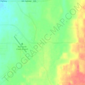
Nom : Carte topographique Red Earth Creek, altitude, relief.
Altitude moyenne : 549 m
Altitude minimum : 526 m
Altitude maximum : 584 m
Faire un don
Équipez-vous pour votre prochaine aventure :
En tant que Partenaire Amazon, ce site perçoit une commission sur les achats éligibles sans surcoût pour vous.