
Carte topographique Opol
Cliquez sur la carte pour afficher l’altitude.
À propos de cette carte
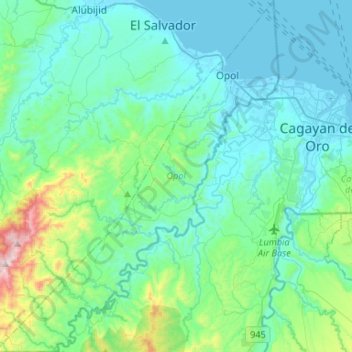
Nom : Carte topographique Opol, altitude, relief.
Lieu : Opol, Misamis Oriental, Northern Mindanao, 9017, Philippines (8.31620 124.40028 8.57639 124.61313)
Altitude moyenne : 155 m
Altitude minimum : -3 m
Altitude maximum : 995 m
Autres cartes topographiques
Cliquez sur une carte pour visualiser sa topographie, son altitude et son relief.
Mount Balatukan
Philippines > Misamis Oriental
Mount Balatukan is a stratovolcano with a listed elevation of 2,450 meters (8,040 ft) asl (GVP). The Philippine Institute of Volcanology and Seismology (PHIVOLCS).
Altitude moyenne : 1.926 m
Claveria
Philippines > Misamis Oriental
The town has a generally rugged topography, characterized by gently rolling hills and mountains with cliffs and escarpments. The soil is classified as Jasaan clay, with a deep soil profile (greater than 1 m) and rapid drainage. It is generally acidic (pH 3.9 to 5.2), with low cation exchange capacity (CEC),…
Altitude moyenne : 663 m
Gitagum
Philippines > Misamis Oriental
Gitagum is shaped like a native fan. Its broad limestone plain within 0 – 100 meters elevation stretches from Iligan Bay towards the easier part, narrowing down to rise 100–300 meters above the sea level forming low and high relief shale/sandstone hills. Ultra basic high relief hills at the southwestern…
Altitude moyenne : 46 m
Cagayan de Oro River
Philippines > Misamis Oriental > Cagayan De Oro > Balulang
Altitude moyenne : 98 m
Claveria
Philippines > Misamis Oriental
The town has a generally rugged topography, characterized by gently rolling hills and mountains with cliffs and escarpments. The soil is classified as Jasaan clay, with a deep soil profile (greater than 1 m) and rapid drainage. It is generally acidic (pH 3.9 to 5.2), with low cation exchange capacity (CEC),…
Altitude moyenne : 663 m