
Carte topographique Sensweiler
Carte interactive
Cliquez sur la carte pour afficher l’altitude.
À propos de cette carte
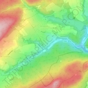
Nom : Carte topographique Sensweiler, altitude, relief.
Altitude moyenne : 524 m
Altitude minimum : 409 m
Altitude maximum : 660 m
Autres cartes topographiques
Cliquez sur une carte pour visualiser sa topographie, son altitude et son relief.
Börfink
Duitsland > Rijnland-Palts > Landkreis Birkenfeld
Börfink, Birkenfeld, Landkreis Birkenfeld, Rijnland-Palts, Duitsland
Altitude moyenne : 618 m
Stipshausen
Duitsland > Rijnland-Palts > Landkreis Birkenfeld
Stipshausen, Herrstein-Rhaunen, Landkreis Birkenfeld, Rijnland-Palts, Duitsland
Altitude moyenne : 512 m
Bergen
Duitsland > Rijnland-Palts > Landkreis Birkenfeld
Bergen, Herrstein-Rhaunen, Landkreis Birkenfeld, Rijnland-Palts, 55608, Duitsland
Altitude moyenne : 355 m
Idar-Oberstein
Duitsland > Rijnland-Palts > Landkreis Birkenfeld
Idar-Oberstein, Landkreis Birkenfeld, Rijnland-Palts, 55743, Duitsland
Altitude moyenne : 406 m
Hettenrodt
Duitsland > Rijnland-Palts > Landkreis Birkenfeld
Hettenrodt, Herrstein-Rhaunen, Landkreis Birkenfeld, Rijnland-Palts, Duitsland
Altitude moyenne : 438 m
Nahetal
Duitsland > Rijnland-Palts > Landkreis Birkenfeld > Hoppstädten-Weiersbach > Mausemühle
Nahetal, L 169, Mausemühle, Hoppstädten-Weiersbach, Birkenfeld, Landkreis Birkenfeld, Rijnland-Palts, 55768, Duitsland
Altitude moyenne : 413 m
Oberhambach
Duitsland > Rijnland-Palts > Landkreis Birkenfeld
Oberhambach, Birkenfeld, Landkreis Birkenfeld, Rijnland-Palts, Duitsland
Altitude moyenne : 497 m
Heimbach
Duitsland > Rijnland-Palts > Landkreis Birkenfeld
Heimbach, Baumholder, Landkreis Birkenfeld, Rijnland-Palts, 55779, Duitsland
Altitude moyenne : 412 m
Huben
Duitsland > Rijnland-Palts > Landkreis Birkenfeld > Hintertiefenbach
Huben, Hintertiefenbach, Herrstein-Rhaunen, Landkreis Birkenfeld, Rijnland-Palts, 55743, Duitsland
Altitude moyenne : 422 m
Krummenau
Duitsland > Rijnland-Palts > Landkreis Birkenfeld > Krummenau
Krummenau, Herrstein-Rhaunen, Landkreis Birkenfeld, Rijnland-Palts, Duitsland
Altitude moyenne : 456 m
Abentheuer
Duitsland > Rijnland-Palts > Landkreis Birkenfeld
Abentheuer, Birkenfeld, Landkreis Birkenfeld, Rijnland-Palts, Duitsland
Altitude moyenne : 526 m