
Faire un don
Équipez-vous pour votre prochaine aventure :
En tant que Partenaire Amazon, ce site perçoit une commission sur les achats éligibles sans surcoût pour vous.
Carte topographique Lupao
Cliquez sur la carte pour afficher l’altitude.
Faire un don
Équipez-vous pour votre prochaine aventure :
En tant que Partenaire Amazon, ce site perçoit une commission sur les achats éligibles sans surcoût pour vous.
Lupao
Lupao belongs to the first type of climate in the Philippines. This type of climate has two (2) pronounced seasons: dry from the month of November to April and Wet during the rest of the year. This type of climate is typically hot, humid and tropical and is generally affected by the neighboring topography and the prevalent wind direction that varies within the year.
Faire un don
Équipez-vous pour votre prochaine aventure :
En tant que Partenaire Amazon, ce site perçoit une commission sur les achats éligibles sans surcoût pour vous.
À propos de cette carte
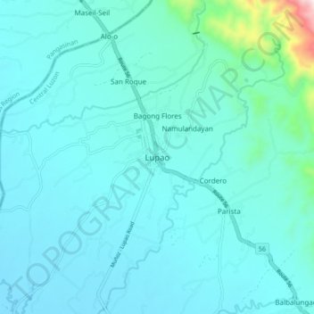
Nom : Carte topographique Lupao, altitude, relief.
Lieu : Lupao, Nueva Ecija, Central Luzon, Philippines (15.83701 120.85952 15.91701 120.93952)
Altitude moyenne : 163 m
Altitude minimum : 89 m
Altitude maximum : 788 m
Faire un don
Équipez-vous pour votre prochaine aventure :
En tant que Partenaire Amazon, ce site perçoit une commission sur les achats éligibles sans surcoût pour vous.
Autres cartes topographiques
Cliquez sur une carte pour visualiser sa topographie, son altitude et son relief.
Pampanga River
Its main tributaries are Peñaranda and the Coronel-Santor rivers on the eastern side of the basin and the Rio Chico River from the northwest side. The Angat River joins the Pampanga River at Calumpit, Bulacan via the Bagbag River. Mount Arayat (elevation: 1,026 metres (3,366 ft)) stands in the middle of the…
Altitude moyenne : 190 m
Pantabangan Dam
Philippines > Nueva Ecija > Pantabangan > Fatima
The dam is a 107 m (351 ft) tall and 1,615 m (5,299 ft) long embankment-type with 12,000,000 cu yd (9,174,658 m3) of homogeneous earth-fill and an impervious core. The crest of the dam is 12 m (39 ft) wide while the widest part of its base is 535 m (1,755 ft). The dam's crest sits at an elevation of 232 m (761…
Altitude moyenne : 210 m
Faire un don
Équipez-vous pour votre prochaine aventure :
En tant que Partenaire Amazon, ce site perçoit une commission sur les achats éligibles sans surcoût pour vous.
Faire un don
Équipez-vous pour votre prochaine aventure :
En tant que Partenaire Amazon, ce site perçoit une commission sur les achats éligibles sans surcoût pour vous.
Talavera
The municipality's terrain is relatively flat, with slope ranging from 0 to 3%. Due to the flat topography, the land is suited for agricultural, commercial or industrial development. It is bordered by Cabanatuan, Llanera, Muñoz, Aliaga, General Mamerto Natividad, Santo Domingo and San Jose.
Altitude moyenne : 49 m