
Carte topographique Newry
Carte interactive
Cliquez sur la carte pour afficher l’altitude.
À propos de cette carte
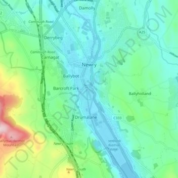
Nom : Carte topographique Newry, altitude, relief.
Lieu : Newry, County Down, Northern Ireland, United Kingdom (54.14495 -6.36011 54.19597 -6.30507)
Altitude moyenne : 73 m
Altitude minimum : -3 m
Altitude maximum : 326 m
Autres cartes topographiques
Cliquez sur une carte pour visualiser sa topographie, son altitude et son relief.
Hillhall
United Kingdom > Northern Ireland > County Down
Hillhall, County Down, Northern Ireland, BT27 5JA, United Kingdom
Altitude moyenne : 61 m
Benraw
United Kingdom > Northern Ireland > County Down
Benraw, County Down, Ulster, Northern Ireland, United Kingdom
Altitude moyenne : 182 m
Banbridge
United Kingdom > Northern Ireland > County Down
Banbridge, County Down, Northern Ireland, BT32 3DB, United Kingdom
Altitude moyenne : 90 m
Carryduff
United Kingdom > Northern Ireland > County Down > Carryduff
Carryduff, County Down, Northern Ireland, BT8 8DN, United Kingdom
Altitude moyenne : 110 m
Newry
United Kingdom > Northern Ireland > County Down > Newry
Newry, County Down, Northern Ireland, BT34 1DG, United Kingdom
Altitude moyenne : 129 m
Slieve Donard
United Kingdom > Northern Ireland > County Down
Slieve Donard, County Down, Northern Ireland, BT33 0HD, United Kingdom
Altitude moyenne : 505 m