
Faire un don
Équipez-vous pour votre prochaine aventure :
En tant que Partenaire Amazon, ce site perçoit une commission sur les achats éligibles sans surcoût pour vous.
Carte topographique Valdín
Cliquez sur la carte pour afficher l’altitude.
Faire un don
Équipez-vous pour votre prochaine aventure :
En tant que Partenaire Amazon, ce site perçoit une commission sur les achats éligibles sans surcoût pour vous.
À propos de cette carte
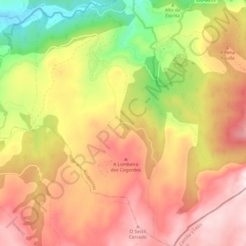
Nom : Carte topographique Valdín, altitude, relief.
Lieu : Valdín, La Vega, Valdeorras, Orense, Galicia, España (42.17226 -6.99646 42.23959 -6.91477)
Altitude moyenne : 1.263 m
Altitude minimum : 853 m
Altitude maximum : 1.599 m
Faire un don
Équipez-vous pour votre prochaine aventure :
En tant que Partenaire Amazon, ce site perçoit une commission sur les achats éligibles sans surcoût pour vous.
Autres cartes topographiques
Cliquez sur une carte pour visualiser sa topographie, son altitude et son relief.
Peña Trevinca
España > Galicia > Valdeorras > La Vega
Peña Trevinca (en asturleonés, Peña Taravinca; en gallego, Pena Trevinca) es la cumbre más elevada de sierra Segundera, que forma parte del conjunto montañoso de los montes de León, en el macizo Galaico-Leonés (España). Se encuentra en el límite provincial de Zamora y Orense, con una altitud según el…
Altitude moyenne : 1.902 m
Faire un don
Équipez-vous pour votre prochaine aventure :
En tant que Partenaire Amazon, ce site perçoit une commission sur les achats éligibles sans surcoût pour vous.