
Faire un don
Équipez-vous pour votre prochaine aventure :
En tant que Partenaire Amazon, ce site perçoit une commission sur les achats éligibles sans surcoût pour vous.
Carte topographique Nimpo Lake
Cliquez sur la carte pour afficher l’altitude.
Faire un don
Équipez-vous pour votre prochaine aventure :
En tant que Partenaire Amazon, ce site perçoit une commission sur les achats éligibles sans surcoût pour vous.
Nimpo Lake
Nimpo Lake is the jumping off point to the wilderness, much of it inaccessible to people except by floatplane or on foot. You can go flightseeing over Hunlen Falls, the third longest freefalling waterfall in Canada, or fly over the multicolored Rainbow Mountains or Monarch Mountain and see the pristine icefields. There is canoeing on the Turner Lake Chain in nearby Tweedsmuir Park, and a number of activities available to visitors of the area. These include fishing, hiking, mountain biking, canoeing, kayaking, hunting, wildlife photography and study of rare and unusual alpine plants at higher elevations. In winter snowmobiling, cross country skiing, snowshoeing and ice skating are popular activities.
Faire un don
Équipez-vous pour votre prochaine aventure :
En tant que Partenaire Amazon, ce site perçoit une commission sur les achats éligibles sans surcoût pour vous.
À propos de cette carte
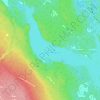
Nom : Carte topographique Nimpo Lake, altitude, relief.
Altitude moyenne : 1.150 m
Altitude minimum : 1.112 m
Altitude maximum : 1.225 m
Faire un don
Équipez-vous pour votre prochaine aventure :
En tant que Partenaire Amazon, ce site perçoit une commission sur les achats éligibles sans surcoût pour vous.
Autres cartes topographiques
Cliquez sur une carte pour visualiser sa topographie, son altitude et son relief.
Mount Juno
Canada > British Columbia > Cariboo Regional District > Area J (West Chilcotin)
Altitude moyenne : 2.219 m
Kondor Lake
Canada > British Columbia > Cariboo Regional District > Area J (West Chilcotin)
Altitude moyenne : 1.718 m
Anahim Lake
Canada > British Columbia > Cariboo Regional District > Area J (West Chilcotin)
Altitude moyenne : 1.101 m
Heckman Pass
Canada > British Columbia > Cariboo Regional District > Area J (West Chilcotin)
Altitude moyenne : 1.519 m
Faire un don
Équipez-vous pour votre prochaine aventure :
En tant que Partenaire Amazon, ce site perçoit une commission sur les achats éligibles sans surcoût pour vous.
Itcha Range
Canada > British Columbia > Cariboo Regional District > Area J (West Chilcotin)
Altitude moyenne : 1.747 m
Ilgachuz Range
Canada > British Columbia > Cariboo Regional District > Area J (West Chilcotin)
The Ilgachuz Range is a name given to an extinct shield volcano in British Columbia, Canada. It is not a mountain range in the normal sense, because it was formed as a single volcano that has been eroded for the past five million years. It lies on the Chilcotin Plateau, located some 350 kilometres (220 mi)…
Altitude moyenne : 2.018 m
Rainbow Range
Canada > British Columbia > Cariboo Regional District > Area J (West Chilcotin)
Altitude moyenne : 1.741 m
Nimpo Lake
Canada > British Columbia > Cariboo Regional District > Area J (West Chilcotin)
Altitude moyenne : 1.131 m
Faire un don
Équipez-vous pour votre prochaine aventure :
En tant que Partenaire Amazon, ce site perçoit une commission sur les achats éligibles sans surcoût pour vous.
Anahim Peak
Canada > British Columbia > Cariboo Regional District > Area J (West Chilcotin)
Altitude moyenne : 1.416 m
Puntzi Mountain
Canada > British Columbia > Cariboo Regional District > Area J (West Chilcotin)
Altitude moyenne : 1.293 m
The Joker
Canada > British Columbia > Cariboo Regional District > Area J (West Chilcotin)
Altitude moyenne : 2.157 m
Great Canyon
Canada > British Columbia > Cariboo Regional District > Area J (West Chilcotin)
Altitude moyenne : 1.220 m
Faire un don
Équipez-vous pour votre prochaine aventure :
En tant que Partenaire Amazon, ce site perçoit une commission sur les achats éligibles sans surcoût pour vous.
Great Canyon
Canada > British Columbia > Cariboo Regional District > Area J (West Chilcotin)
Altitude moyenne : 1.220 m
Map Glacier
Canada > British Columbia > Cariboo Regional District > Area J (West Chilcotin)
Altitude moyenne : 2.037 m