Géolocaliser

Carte topographique Kujalleq

Carte interactive

Cliquez sur la carte pour afficher l’altitude.

À propos de cette carte

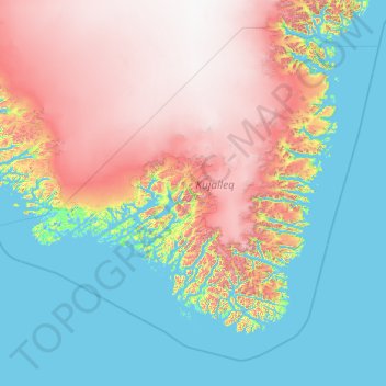
Nom : Carte topographique Kujalleq, altitude, relief.

Lieu : Kujalleq, Groenland (59.51539 -49.03148 62.75806 -41.25332)

Altitude moyenne : 784 m

Altitude minimum : -5 m

Altitude maximum : 2.854 m

Autres cartes topographiques

Cliquez sur une carte pour visualiser sa topographie, son altitude et son relief.

Upernavik

Groenland > Avannaata

Upernavik, Avannaata, Groenland

Altitude moyenne : 13 m

Qaqortoq

Groenland > Qaqortoq

Qaqortoq, Kujalleq, 3920, Groenland

Altitude moyenne : 75 m

Uunartoq Fjord

Groenland

Uunartoq Fjord, Groenland

Altitude moyenne : 283 m

Sermersooq

Groenland

Sermersooq, Groenland

Altitude moyenne : 1.116 m

Nuuk

Groenland

Nuuk, Sermersooq, 3900, Groenland

Altitude moyenne : 76 m

Avannaata

Groenland

Avannaata, Groenland

Altitude moyenne : 1.382 m

Ilulissat

Groenland > Ilulissat

Ilulissat, Avannaata, 3952, Groenland

Altitude moyenne : 68 m

Qeqertarsuaq

Groenland

Qeqertarsuaq, Qeqertalik, Groenland

Altitude moyenne : 424 m