
Faire un don
Équipez-vous pour votre prochaine aventure :
En tant que Partenaire Amazon, ce site perçoit une commission sur les achats éligibles sans surcoût pour vous.
Carte topographique Berg
Cliquez sur la carte pour afficher l’altitude.
Faire un don
Équipez-vous pour votre prochaine aventure :
En tant que Partenaire Amazon, ce site perçoit une commission sur les achats éligibles sans surcoût pour vous.
À propos de cette carte
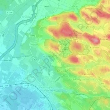
Nom : Carte topographique Berg, altitude, relief.
Altitude moyenne : 443 m
Altitude minimum : 396 m
Altitude maximum : 530 m
Faire un don
Équipez-vous pour votre prochaine aventure :
En tant que Partenaire Amazon, ce site perçoit une commission sur les achats éligibles sans surcoût pour vous.
Autres cartes topographiques
Cliquez sur une carte pour visualiser sa topographie, son altitude et son relief.
Friedrichshafen
Germany > Baden-Württemberg > Bodenseekreis
Friedrichshafen is located on a gently curved bay on the north shore of Lake Constance and on the southwest edge of the Schussen. The city is over an altitude of 395.2 m above sea level. NHH on the shores of Lake Constance up to 501.6 m in Ailingen. The core city is located not far to the west of the…
Altitude moyenne : 441 m
Faire un don
Équipez-vous pour votre prochaine aventure :
En tant que Partenaire Amazon, ce site perçoit une commission sur les achats éligibles sans surcoût pour vous.