
Faire un don
Équipez-vous pour votre prochaine aventure :
En tant que Partenaire Amazon, ce site perçoit une commission sur les achats éligibles sans surcoût pour vous.
Carte topographique Biljurashi
Cliquez sur la carte pour afficher l’altitude.
Faire un don
Équipez-vous pour votre prochaine aventure :
En tant que Partenaire Amazon, ce site perçoit une commission sur les achats éligibles sans surcoût pour vous.
Biljurashi
Baljurashi (Arabic: بَـلْـجُـرَشِي) or Biljurashi (Arabic: بِـلْـجُـرَشِي) is a city in Al Bahah Region, south-western Saudi Arabia. It is located at around 19°51′40″N 41°33′40″E / 19.8612090°N 41.5609769°E / 19.8612090; 41.5609769 in the elevation of cca 2,000 metres (6,600 feet). It was the capital of the region which includes the tribes of Ghamid and Zahran. It is a medium-sized city in Al Bahah Region. The temperature usually varies between 2 °C (36 °F) in winter and 30 °C (86 °F) in summer. The best time for a visit is from mid-August till the end of September. Most of the native people of Baljurashi live outside it; however, a great number of them spend their summer vacations in the city, which explains the massive increase in population number during summer.
Faire un don
Équipez-vous pour votre prochaine aventure :
En tant que Partenaire Amazon, ce site perçoit une commission sur les achats éligibles sans surcoût pour vous.
À propos de cette carte
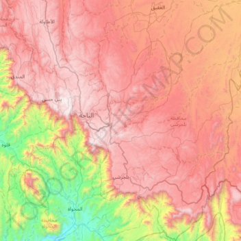
Nom : Carte topographique Biljurashi, altitude, relief.
Lieu : Biljurashi, بني كبير, Al-Bahah Province, Saudi Arabia (19.69809 41.50283 20.29958 41.97897)
Altitude moyenne : 1.528 m
Altitude minimum : 268 m
Altitude maximum : 2.563 m
Faire un don
Équipez-vous pour votre prochaine aventure :
En tant que Partenaire Amazon, ce site perçoit une commission sur les achats éligibles sans surcoût pour vous.