
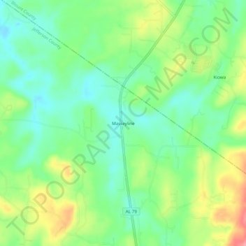
Carte topographique Masseyline
Carte interactive
Cliquez sur la carte pour afficher l’altitude.
À propos de cette carte
Nom : Carte topographique Masseyline, altitude, relief.
Lieu : Masseyline, Jefferson County, Alabama, 35172, United States (33.77177 -86.70610 33.81177 -86.66610)
Altitude moyenne : 173 m
Altitude minimum : 136 m
Altitude maximum : 235 m
Autres cartes topographiques
Cliquez sur une carte pour visualiser sa topographie, son altitude et son relief.
Bessemer
United States > Alabama > Jefferson County
Bessemer, Jefferson County, Alabama, United States
Altitude moyenne : 175 m
Avon Park
United States > Alabama > Jefferson County > Birmingham
Avon Park, Birmingham, Jefferson County, Alabama, 35212, United States
Altitude moyenne : 189 m
Madison
United States > Alabama > Jefferson County > Brighton
Madison, Brighton, Jefferson County, Alabama, 35228, United States
Altitude moyenne : 163 m
Martins
United States > Alabama > Jefferson County > Birmingham
Martins, Birmingham, Jefferson County, Alabama, 35028, United States
Altitude moyenne : 176 m
Trussville
United States > Alabama > Jefferson County
Trussville, Jefferson County, Alabama, United States
Altitude moyenne : 265 m
Center Point
United States > Alabama > Jefferson County
Center Point, Jefferson County, Alabama, 35215, United States
Altitude moyenne : 245 m
Red Wine
United States > Alabama > Jefferson County > Graysville
Red Wine, Graysville, Jefferson County, Alabama, 35073, United States
Altitude moyenne : 162 m
Douglasville
United States > Alabama > Jefferson County > Birmingham > Douglasville
Douglasville, Birmingham, Jefferson County, Alabama, 35234, United States
Altitude moyenne : 182 m
Birmingham
United States > Alabama > Jefferson County
Birmingham, Jefferson County, Alabama, United States
Altitude moyenne : 193 m
Leeds
United States > Alabama > Jefferson County > Leeds
Leeds, Jefferson County, Alabama, United States
Altitude moyenne : 237 m
Irondale
United States > Alabama > Jefferson County
Irondale, Jefferson County, Alabama, 35210, United States
Altitude moyenne : 236 m
Rock Creek
United States > Alabama > Jefferson County
Rock Creek, Jefferson County, Alabama, United States
Altitude moyenne : 148 m