
Carte topographique Parc de la Rive-Boisée
Cliquez sur la carte pour afficher l’altitude.
À propos de cette carte
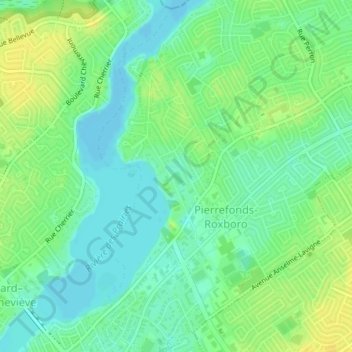
Nom : Carte topographique Parc de la Rive-Boisée, altitude, relief.
Altitude moyenne : 29 m
Altitude minimum : 19 m
Altitude maximum : 40 m
Autres cartes topographiques
Cliquez sur une carte pour visualiser sa topographie, son altitude et son relief.
Mount Royal
Canada > Quebec > Urban agglomeration of Montreal > Montreal
The hill is part of the Monteregian Hills situated between the Laurentians and the Appalachian Mountains. It gave its Latin name, Mons Regius, to the Monteregian chain. The hill consists of three peaks: Colline de la Croix (or Mont Royal proper) at 233 m (764 ft), Colline d'Outremont (or Mount Murray, in the…
Altitude moyenne : 111 m
Parc-nature du Bois-de-Liesse
Canada > Quebec > Urban agglomeration of Montreal > Montreal
Altitude moyenne : 28 m
Parc Léon-Provancher
Canada > Quebec > Urban agglomeration of Montreal > Montreal
Altitude moyenne : 53 m
Saint Helen's Island
Canada > Quebec > Urban agglomeration of Montreal > Montreal
Altitude moyenne : 15 m
Mount Royal Park
Canada > Quebec > Urban agglomeration of Montreal > Montreal
The mountain is part of the Monteregian Hills situated between the Laurentians and the Appalachian Mountains. It gave its Latin name, Mons Regius, to the Monteregian chain. The mountain consists of three peaks: Colline de la Croix (or Mont Royal proper) at 233 m (764 ft), Colline d'Outremont (or Mount Murray,…
Altitude moyenne : 110 m
Cap Saint-Jacques
Canada > Quebec > Urban agglomeration of Montreal > Montreal
Altitude moyenne : 25 m
Mount Royal
Canada > Quebec > Urban agglomeration of Montreal > Montreal
The mountain is part of the Monteregian Hills situated between the Laurentians and the Appalachian Mountains. It gave its Latin name, Mons Regius, to the Monteregian chain. The mountain consists of three peaks: Colline de la Croix (or Mont Royal proper) at 233 m (764 ft), Colline d'Outremont (or Mount Murray,…
Altitude moyenne : 111 m
Colline de l'Abri
Canada > Quebec > Urban agglomeration of Montreal > Montreal
Altitude moyenne : 120 m