
Carte topographique Woodbridge
Carte interactive
Cliquez sur la carte pour afficher l’altitude.
À propos de cette carte
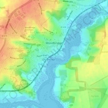
Nom : Carte topographique Woodbridge, altitude, relief.
Lieu : Woodbridge, East Suffolk, Suffolk, England, United Kingdom (52.07639 1.28439 52.10577 1.32901)
Altitude moyenne : 19 m
Altitude minimum : -5 m
Altitude maximum : 46 m
The Suffolk Traveller suggests a similar origin to The Dictionary but originating from a bridge over a hollow way that leads from Woodbridge Market Place to the Ipswich. But this is disputed by Rev. Thomas Carthew, then perpetual curate of Woodbridge who points out that the bridge had existed for less than a hundred years at that point and therefore was not old enough to be the source of the name. He instead suggests Oden or Woden (Odin) and Burgh, Bury, or Brigg (town). The Topographical Dictionary of England suggests a combination of Woden and Bryge.
Autres cartes topographiques
Cliquez sur une carte pour visualiser sa topographie, son altitude et son relief.
Kessingland
United Kingdom > England > Suffolk > East Suffolk
Kessingland, East Suffolk, Suffolk, England, United Kingdom
Altitude moyenne : 8 m
Eygpt Wood
United Kingdom > England > Suffolk > East Suffolk > Walton
Eygpt Wood, Trimley St Martin, Walton, East Suffolk, Suffolk, England, United Kingdom
Altitude moyenne : 16 m
Heveningham
United Kingdom > England > Suffolk > East Suffolk
Heveningham, East Suffolk, Suffolk, England, United Kingdom
Altitude moyenne : 42 m
Felixstowe
United Kingdom > England > Suffolk > East Suffolk > Felixstowe
Felixstowe, East Suffolk, Suffolk, England, United Kingdom
Altitude moyenne : 6 m
Parham
United Kingdom > England > Suffolk > East Suffolk
Parham, East Suffolk, Suffolk, England, United Kingdom
Altitude moyenne : 37 m