Géolocaliser

Carte topographique Troll tongue

Carte interactive

Cliquez sur la carte pour afficher l’altitude.

À propos de cette carte

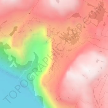
Nom : Carte topographique Troll tongue, altitude, relief.

Lieu : Troll tongue, Ullensvang, Vestland, Norway (60.13291 6.75395 60.13301 6.75405)

Altitude moyenne : 1.091 m

Altitude minimum : 446 m

Altitude maximum : 1.469 m

Autres cartes topographiques

Cliquez sur une carte pour visualiser sa topographie, son altitude et son relief.

Loen

Norway > Vestland

Loen, Stryn, Vestland, 6789, Norway

Altitude moyenne : 381 m

Stord

Norway > Vestland

Stord, Vestland, Norway

Altitude moyenne : 95 m

Myrkdalen

Norway > Vestland

Myrkdalen, Voss, Vestland, Norway

Altitude moyenne : 575 m

Vikaneset

Norway > Vestland

Vikaneset, Alver, Vestland, 5994, Norway

Altitude moyenne : 129 m

Osterøy

Norway > Vestland

Osterøy, Vestland, 5284, Norway, Preikestolen

Altitude moyenne : 262 m

Gloppen

Norway > Vestland

Gloppen, Vestland, Norway

Altitude moyenne : 606 m

Lofthus

Norway > Vestland

Lofthus, Ullensvang, Vestland, 5781, Norway

Altitude moyenne : 247 m

Fitjar

Norway > Vestland

Fitjar, Vestland, 5419, Norway

Altitude moyenne : 92 m

Vik

Norway > Vestland

Vik, Vestland, Norway

Altitude moyenne : 739 m

Sognefjorden

Norway > Vestland

Sognefjorden, Gulen, Vestland, Norway

Altitude moyenne : 0 m

Florø

Norway > Vestland > Florø

Florø, Kinn, Vestland, 6906, Norway

Altitude moyenne : 13 m

Sogndal

Norway > Vestland

Sogndal, Vestland, Norway

Altitude moyenne : 725 m

Bergen

Norway > Vestland

Bergen, Vestland, Norway

Altitude moyenne : 125 m

Stryn

Norway > Vestland

Stryn, Vestland, Norway

Altitude moyenne : 882 m

Aurland

Norway > Vestland

Aurland, Vestland, Norway

Altitude moyenne : 1.102 m