
Carte topographique Hadleigh
Cliquez sur la carte pour afficher l’altitude.
À propos de cette carte
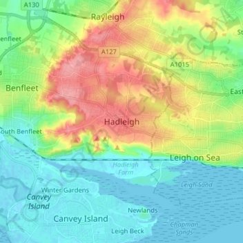
Nom : Carte topographique Hadleigh, altitude, relief.
Lieu : Hadleigh, Castle Point, Essex, England, SS7 2RD, United Kingdom (51.51392 0.56870 51.59392 0.64870)
Altitude moyenne : 29 m
Altitude minimum : -1 m
Altitude maximum : 87 m
Autres cartes topographiques
Cliquez sur une carte pour visualiser sa topographie, son altitude et son relief.
Canvey Island
United Kingdom > England > Essex > Castle Point > Canvey
In 1607 the Elizabethan antiquarian William Camden noted in his work Britannia (a topographical and historical survey of all of Great Britain and Ireland) that Canvey Island (which he called Island Convennon) was documented in the 2nd century by the Alexandrian geographer Ptolemy. In his work Geographia,…
Altitude moyenne : 10 m
Canvey Island
United Kingdom > England > Essex > Castle Point > Canvey Island
In 1607 the Elizabethan antiquarian William Camden noted in his work Britannia (a topographical and historical survey of all of Great Britain and Ireland) that Canvey Island (which he called Island Convennon) was documented in the 2nd century by the Alexandrian geographer Ptolemy. In his work Geographia,…
Altitude moyenne : 10 m