
Carte topographique Ströbitz
Carte interactive
Cliquez sur la carte pour afficher l’altitude.
À propos de cette carte
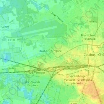
Nom : Carte topographique Ströbitz, altitude, relief.
Lieu : Ströbitz, Cottbus, Brandenburg, 03046, Deutschland (51.73403 14.27508 51.78168 14.32929)
Altitude moyenne : 71 m
Altitude minimum : 59 m
Altitude maximum : 85 m
Autres cartes topographiques
Cliquez sur une carte pour visualiser sa topographie, son altitude et son relief.
Cottbus
Deutschland > Brandenburg > Cottbus
Cottbus, Brandenburg, 03046, Deutschland
Altitude moyenne : 79 m
Hermannsberg
Deutschland > Brandenburg > Cottbus
Hermannsberg, Cottbus, Brandenburg, 03042, Deutschland
Altitude moyenne : 76 m
Saspow
Deutschland > Brandenburg > Cottbus
Saspow, Cottbus, Brandenburg, Deutschland
Altitude moyenne : 68 m
Kiekebusch
Deutschland > Brandenburg > Cottbus > Kiekebusch
Kiekebusch, Cottbus, Brandenburg, 03051, Deutschland
Altitude moyenne : 80 m
Madlow
Deutschland > Brandenburg > Cottbus > Madlow
Madlow, Cottbus, Brandenburg, 03050, Deutschland
Altitude moyenne : 81 m