
Carte topographique South East England
Carte interactive
Cliquez sur la carte pour afficher l’altitude.
À propos de cette carte
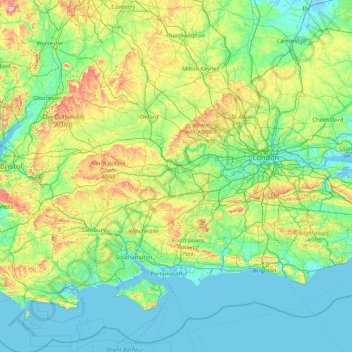
Nom : Carte topographique South East England, altitude, relief.
Lieu : South East England, England, United Kingdom (50.57468 -1.95728 52.19632 1.45177)
Altitude moyenne : 69 m
Altitude minimum : -3 m
Altitude maximum : 491 m
Near Weybridge are the UK headquarters of Sony with SSP Group (situated in Byfleet) and Procter & Gamble (next door to each other on The Heights Business Park near the former Brooklands racing circuit) with Kia Motors UK and Petroleum Geo-Services UK, and Gallaher Group (cigarettes) is to the north, next to the Brooklands Museum; to the east is Verint Systems UK on the B374. In Weybridge are the local newspaper group Newsquest, Yamaha Motors UK; BAE Systems Regional Aircraft is on the Brooklands Ind Park off the A318 (since 2001 it has no longer manufactured). On Sprint Ind Est in Byfleet, west of Weybridge, off the A318, AIM Altitude (former Henshalls) make cabin galleys for airliners. The Central Veterinary Laboratory, which is run by the Veterinary Laboratories Agency, with the Animal and Plant Health Agency, is in New Haw to the west on the other side of the M25. Mouchel is in West Byfleet.
Autres cartes topographiques
Cliquez sur une carte pour visualiser sa topographie, son altitude et son relief.
London
United Kingdom > England > London
London, Greater London, England, SW1A 2DX, United Kingdom
Altitude moyenne : 42 m
London
London, Greater London, England, United Kingdom
Altitude moyenne : 66 m
Bristol
United Kingdom > England > City of Bristol
Bristol, City of Bristol, West of England, England, United Kingdom
Altitude moyenne : 55 m
Greater Manchester
Greater Manchester, England, United Kingdom
Altitude moyenne : 141 m
The Cotswolds National Landscape
United Kingdom > England > Gloucestershire
The Cotswolds National Landscape, Gloucestershire, West of England, England, United Kingdom
Altitude moyenne : 109 m
Gloucestershire
Gloucestershire, England, United Kingdom
Altitude moyenne : 99 m
Liverpool
Liverpool, Liverpool City Region, England, United Kingdom
Altitude moyenne : 26 m
West Midlands
United Kingdom > England > Warwickshire
West Midlands, Warwickshire, West Midlands Combined Authority, England, United Kingdom
Altitude moyenne : 113 m
Lake District National Park
Lake District National Park, England, United Kingdom
Altitude moyenne : 206 m
City of London
United Kingdom > England > City of London > City of London
City of London, England, EC2V 5AE, United Kingdom
Altitude moyenne : 42 m
Brighton
United Kingdom > England > Brighton and Hove
Brighton, Brighton and Hove, England, United Kingdom
Altitude moyenne : 64 m
Hampstead Heath
United Kingdom > England > London
Hampstead Heath, Gospel Oak, London Borough of Camden, London, Greater London, England, United Kingdom
Altitude moyenne : 94 m
Lancashire
Lancashire, North West England, England, United Kingdom
Altitude moyenne : 153 m
Gloucester
United Kingdom > England > Gloucestershire
Gloucester, Gloucestershire, England, United Kingdom
Altitude moyenne : 36 m
Lincoln
United Kingdom > England > Lincolnshire
Lincoln, Lincolnshire, England, United Kingdom
Altitude moyenne : 29 m
Hull
United Kingdom > England > Kingston upon Hull
Hull, Kingston upon Hull, England, HU1 3RJ, United Kingdom
Altitude moyenne : 21 m
Nottingham
United Kingdom > England > Nottinghamshire
Nottingham, England, United Kingdom
Altitude moyenne : 56 m
Durham
United Kingdom > England > County Durham
Durham, County Durham, North East, England, DH1 3NG, United Kingdom
Altitude moyenne : 119 m
Leeds
United Kingdom > England > Leeds
Leeds, Yorkshire and the Humber, England, LS1 6AL, United Kingdom
Altitude moyenne : 94 m
Bath
United Kingdom > England > Bath and North East Somerset
Bath, Bath and North East Somerset, West of England, England, United Kingdom
Altitude moyenne : 100 m
Birmingham
Birmingham, West Midlands Combined Authority, England, United Kingdom
Altitude moyenne : 138 m
Newcastle upon Tyne
Newcastle upon Tyne, North of Tyne, England, United Kingdom
Altitude moyenne : 57 m
Sheffield
Sheffield, South Yorkshire, England, United Kingdom
Altitude moyenne : 168 m
North Yorkshire
North Yorkshire, Yorkshire and the Humber, England, United Kingdom
Altitude moyenne : 153 m
Canterbury
United Kingdom > England > Kent
Canterbury, Kent, England, United Kingdom
Altitude moyenne : 51 m
East of England
East of England, England, United Kingdom
Altitude moyenne : 39 m
Greater London
Greater London, England, United Kingdom
Altitude moyenne : 66 m
Norwich
United Kingdom > England > Norfolk
Norwich, Norfolk, England, United Kingdom
Altitude moyenne : 28 m
Leicester
United Kingdom > England > Leicestershire
Leicester, Leicestershire, England, LE1 5YA, United Kingdom
Altitude moyenne : 109 m
Buxton
United Kingdom > England > Derbyshire > High Peak
Buxton, High Peak, Derbyshire, England, United Kingdom
Altitude moyenne : 334 m
Shropshire
Shropshire, West Midlands, England, United Kingdom
Altitude moyenne : 166 m
Wirral
Wirral, Liverpool City Region, England, United Kingdom
Altitude moyenne : 21 m
Peak District National Park
United Kingdom > England > Derbyshire
Peak District National Park, Derbyshire, South Yorkshire, England, United Kingdom
Altitude moyenne : 225 m
Corby
United Kingdom > England > North Northamptonshire > Corby
Corby, North Northamptonshire, East Midlands, England, United Kingdom
Altitude moyenne : 98 m
Wakefield
Wakefield, West Yorkshire, England, United Kingdom
Altitude moyenne : 88 m
Plymouth
United Kingdom > England > Devon > Plymouth
Plymouth, Devon, South West England, England, PL1 1HH, United Kingdom
Altitude moyenne : 81 m
Holt
United Kingdom > England > Worcestershire > Malvern Hills
Holt, Malvern Hills, Worcestershire, England, United Kingdom
Altitude moyenne : 60 m
Huddersfield
United Kingdom > England > Kirklees
Huddersfield, Kirklees, West Yorkshire, England, HD1 2AA, United Kingdom
Altitude moyenne : 145 m